You are here: Home > Network List > TX - Texas Seismological Network Stations List
> Station MB02 Rankin > Earthquake Result Viewer
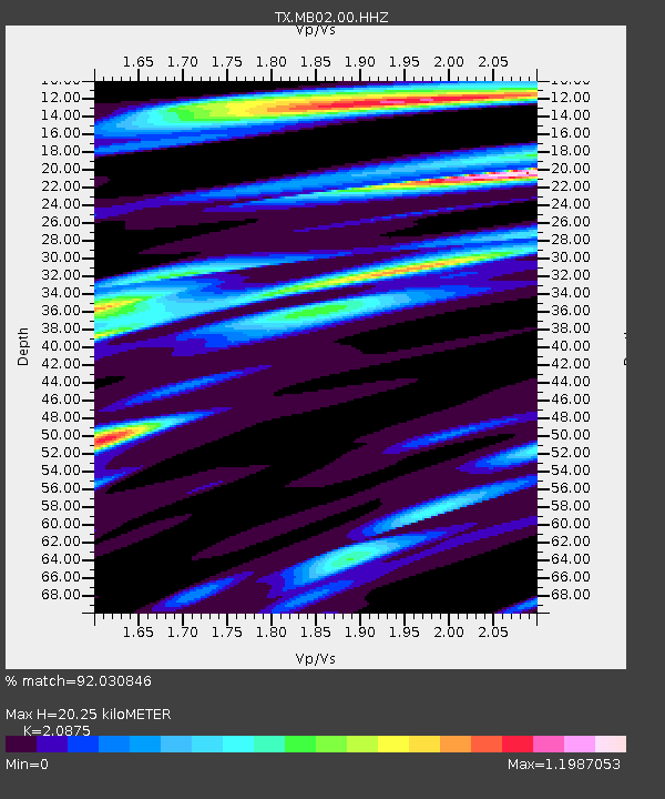
MB02 Rankin - Earthquake Result Viewer
| Earthquake location: |
Leeward Islands |
| Earthquake latitude/longitude: |
16.2/-62.0 |
| Earthquake time(UTC): |
2023/01/20 (020) 11:23:40 GMT |
| Earthquake Depth: |
165 km |
| Earthquake Magnitude: |
5.8 Mi |
| Earthquake Catalog/Contributor: |
NEIC PDE/pt |
|
| Network: |
TX Texas Seismological Network |
| Station: |
MB02 Rankin |
| Lat/Lon: |
31.20 N/102.04 W |
| Elevation: |
768 m |
|
| Distance: |
39.3 deg |
| Az: |
299.578 deg |
| Baz: |
102.859 deg |
| Ray Param: |
0.07445004 |
| Estimated Moho Depth: |
20.25 km |
| Estimated Crust Vp/Vs: |
2.09 |
| Assumed Crust Vp: |
6.121 km/s |
| Estimated Crust Vs: |
2.932 km/s |
| Estimated Crust Poisson's Ratio: |
0.35 |
|
| Radial Match: |
92.030846 % |
| Radial Bump: |
305 |
| Transverse Match: |
77.867325 % |
| Transverse Bump: |
400 |
| SOD ConfigId: |
29823551 |
| Insert Time: |
2023-02-03 11:54:39.850 +0000 |
| GWidth: |
2.5 |
| Max Bumps: |
400 |
| Tol: |
0.001 |
|

Signal To Noise
| Channel | StoN | STA | LTA |
| TX:MB02:00:HHZ:20230120T11:30:22.519989Z | 14.199875 | 1.7709424E-6 | 1.2471536E-7 |
| TX:MB02:00:HH1:20230120T11:30:22.519989Z | 1.5532469 | 2.28081E-7 | 1.4684144E-7 |
| TX:MB02:00:HH2:20230120T11:30:22.519989Z | 11.346173 | 1.0471906E-6 | 9.2294606E-8 |
| Arrivals |
| Ps | 3.8 SECOND |
| PpPs | 9.7 SECOND |
| PsPs/PpSs | 13 SECOND |


