You are here: Home > Network List > TA - USArray Transportable Network (new EarthScope stations) Stations List
> Station G21A Lodge Grass, MT, USA > Earthquake Result Viewer
G21A Lodge Grass, MT, USA - Earthquake Result Viewer
| Earthquake location: |
Near Coast Of Central Chile |
| Earthquake latitude/longitude: |
-34.3/-71.9 |
| Earthquake time(UTC): |
2010/03/11 (070) 14:39:43 GMT |
| Earthquake Depth: |
11 km |
| Earthquake Magnitude: |
6.7 MB, 7.0 MS, 6.9 MW, 6.9 MW |
| Earthquake Catalog/Contributor: |
WHDF/NEIC |
|
| Network: |
TA USArray Transportable Network (new EarthScope stations) |
| Station: |
G21A Lodge Grass, MT, USA |
| Lat/Lon: |
45.22 N/107.21 W |
| Elevation: |
1227 m |
|
| Distance: |
85.4 deg |
| Az: |
335.803 deg |
| Baz: |
151.302 deg |
| Ray Param: |
0.04480932 |
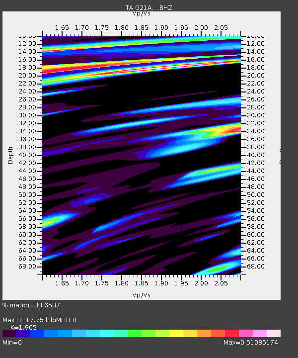
| Estimated Moho Depth: |
17.75 km |
| Estimated Crust Vp/Vs: |
1.90 |
| Assumed Crust Vp: |
6.178 km/s |
| Estimated Crust Vs: |
3.243 km/s |
| Estimated Crust Poisson's Ratio: |
0.31 |
|
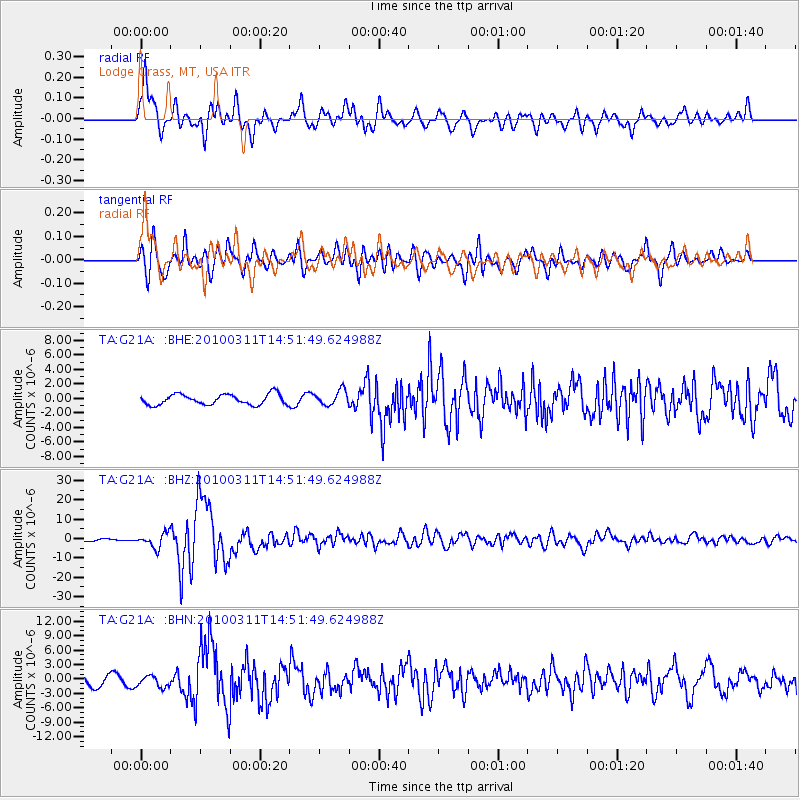
| Radial Match: |
88.6587 % |
| Radial Bump: |
400 |
| Transverse Match: |
89.226204 % |
| Transverse Bump: |
400 |
| SOD ConfigId: |
299721 |
| Insert Time: |
2010-04-26 22:04:29.486 +0000 |
| GWidth: |
2.5 |
| Max Bumps: |
400 |
| Tol: |
0.001 |
|
Signal To Noise
| Channel | StoN | STA | LTA |
| TA:G21A: :BHZ:20100311T14:51:49.624988Z | 5.375708 | 3.6926644E-6 | 6.8691685E-7 |
| TA:G21A: :BHN:20100311T14:51:49.624988Z | 0.9927988 | 1.150436E-6 | 1.1587805E-6 |
| TA:G21A: :BHE:20100311T14:51:49.624988Z | 1.4349467 | 1.0253342E-6 | 7.1454514E-7 |
| Arrivals |
| Ps | 2.7 SECOND |
| PpPs | 8.2 SECOND |
| PsPs/PpSs | 11 SECOND |


