You are here: Home > Network List > TA - USArray Transportable Network (new EarthScope stations) Stations List
> Station I20A Worland, WY, USA > Earthquake Result Viewer
I20A Worland, WY, USA - Earthquake Result Viewer
| Earthquake location: |
Near Coast Of Central Chile |
| Earthquake latitude/longitude: |
-34.3/-71.9 |
| Earthquake time(UTC): |
2010/03/11 (070) 14:39:43 GMT |
| Earthquake Depth: |
11 km |
| Earthquake Magnitude: |
6.7 MB, 7.0 MS, 6.9 MW, 6.9 MW |
| Earthquake Catalog/Contributor: |
WHDF/NEIC |
|
| Network: |
TA USArray Transportable Network (new EarthScope stations) |
| Station: |
I20A Worland, WY, USA |
| Lat/Lon: |
43.95 N/108.13 W |
| Elevation: |
1342 m |
|
| Distance: |
84.6 deg |
| Az: |
334.604 deg |
| Baz: |
150.552 deg |
| Ray Param: |
0.045380645 |
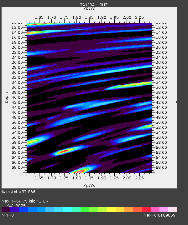
| Estimated Moho Depth: |
69.75 km |
| Estimated Crust Vp/Vs: |
1.80 |
| Assumed Crust Vp: |
6.161 km/s |
| Estimated Crust Vs: |
3.418 km/s |
| Estimated Crust Poisson's Ratio: |
0.28 |
|
| Radial Match: |
87.856 % |
| Radial Bump: |
400 |
| Transverse Match: |
73.16128 % |
| Transverse Bump: |
400 |
| SOD ConfigId: |
299721 |
| Insert Time: |
2010-04-26 22:04:54.434 +0000 |
| GWidth: |
2.5 |
| Max Bumps: |
400 |
| Tol: |
0.001 |
|
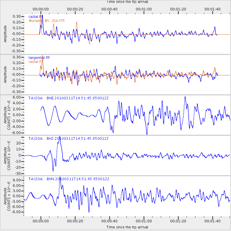
Signal To Noise
| Channel | StoN | STA | LTA |
| TA:I20A: :BHZ:20100311T14:51:45.650012Z | 4.9677763 | 2.9949833E-6 | 6.028821E-7 |
| TA:I20A: :BHN:20100311T14:51:45.650012Z | 0.7050187 | 8.7404766E-7 | 1.239751E-6 |
| TA:I20A: :BHE:20100311T14:51:45.650012Z | 0.5573971 | 9.383496E-7 | 1.683449E-6 |
| Arrivals |
| Ps | 9.3 SECOND |
| PpPs | 31 SECOND |
| PsPs/PpSs | 40 SECOND |


