You are here: Home > Network List > TX - Texas Seismological Network Stations List
> Station SNAG San Augustine > Earthquake Result Viewer
SNAG San Augustine - Earthquake Result Viewer
| Earthquake location: |
Leeward Islands |
| Earthquake latitude/longitude: |
16.2/-62.0 |
| Earthquake time(UTC): |
2023/01/20 (020) 11:23:40 GMT |
| Earthquake Depth: |
165 km |
| Earthquake Magnitude: |
5.8 Mi |
| Earthquake Catalog/Contributor: |
NEIC PDE/pt |
|
| Network: |
TX Texas Seismological Network |
| Station: |
SNAG San Augustine |
| Lat/Lon: |
31.52 N/94.18 W |
| Elevation: |
84 m |
|
| Distance: |
33.0 deg |
| Az: |
303.314 deg |
| Baz: |
109.956 deg |
| Ray Param: |
0.07792474 |
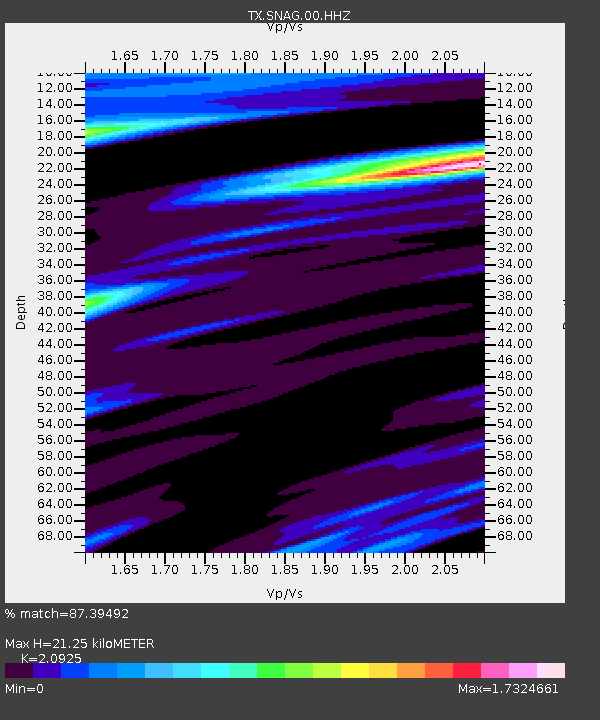
| Estimated Moho Depth: |
21.25 km |
| Estimated Crust Vp/Vs: |
2.09 |
| Assumed Crust Vp: |
5.738 km/s |
| Estimated Crust Vs: |
2.742 km/s |
| Estimated Crust Poisson's Ratio: |
0.35 |
|
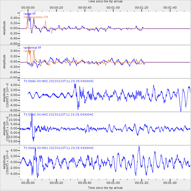
| Radial Match: |
87.39492 % |
| Radial Bump: |
309 |
| Transverse Match: |
70.14936 % |
| Transverse Bump: |
400 |
| SOD ConfigId: |
29823551 |
| Insert Time: |
2023-02-03 11:55:46.221 +0000 |
| GWidth: |
2.5 |
| Max Bumps: |
400 |
| Tol: |
0.001 |
|
Signal To Noise
| Channel | StoN | STA | LTA |
| TX:SNAG:00:HHZ:20230120T11:29:28.649994Z | 14.273226 | 7.017673E-6 | 4.916669E-7 |
| TX:SNAG:00:HH1:20230120T11:29:28.649994Z | 2.114421 | 1.5787858E-6 | 7.466753E-7 |
| TX:SNAG:00:HH2:20230120T11:29:28.649994Z | 3.0295687 | 1.8754722E-6 | 6.1905587E-7 |
| Arrivals |
| Ps | 4.3 SECOND |
| PpPs | 11 SECOND |
| PsPs/PpSs | 15 SECOND |


