You are here: Home > Network List > TX - Texas Seismological Network Stations List
> Station WTFS Witchita Falls > Earthquake Result Viewer
WTFS Witchita Falls - Earthquake Result Viewer
| Earthquake location: |
Leeward Islands |
| Earthquake latitude/longitude: |
16.2/-62.0 |
| Earthquake time(UTC): |
2023/01/20 (020) 11:23:40 GMT |
| Earthquake Depth: |
165 km |
| Earthquake Magnitude: |
5.8 Mi |
| Earthquake Catalog/Contributor: |
NEIC PDE/pt |
|
| Network: |
TX Texas Seismological Network |
| Station: |
WTFS Witchita Falls |
| Lat/Lon: |
33.77 N/98.46 W |
| Elevation: |
277 m |
|
| Distance: |
37.1 deg |
| Az: |
304.896 deg |
| Baz: |
108.95 deg |
| Ray Param: |
0.0757284 |
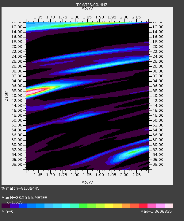
| Estimated Moho Depth: |
38.25 km |
| Estimated Crust Vp/Vs: |
1.62 |
| Assumed Crust Vp: |
6.426 km/s |
| Estimated Crust Vs: |
3.955 km/s |
| Estimated Crust Poisson's Ratio: |
0.20 |
|
| Radial Match: |
81.66445 % |
| Radial Bump: |
238 |
| Transverse Match: |
51.673904 % |
| Transverse Bump: |
277 |
| SOD ConfigId: |
29823551 |
| Insert Time: |
2023-02-03 11:55:49.299 +0000 |
| GWidth: |
2.5 |
| Max Bumps: |
400 |
| Tol: |
0.001 |
|

Signal To Noise
| Channel | StoN | STA | LTA |
| TX:WTFS:00:HHZ:20230120T11:30:04.125Z | 17.850292 | 4.4589137E-6 | 2.49795E-7 |
| TX:WTFS:00:HH1:20230120T11:30:04.125Z | 4.4943733 | 1.9305546E-6 | 4.2954926E-7 |
| TX:WTFS:00:HH2:20230120T11:30:04.125Z | 7.0612082 | 1.9248828E-6 | 2.7259964E-7 |
| Arrivals |
| Ps | 4.0 SECOND |
| PpPs | 14 SECOND |
| PsPs/PpSs | 18 SECOND |


