You are here: Home > Network List > US - United States National Seismic Network Stations List
> Station AGMN Agassiz National Wildlife Refuge, Minnesota, USA > Earthquake Result Viewer
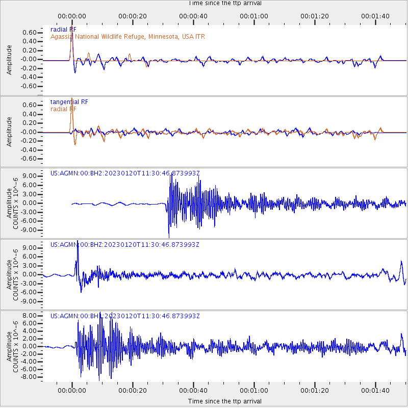
AGMN Agassiz National Wildlife Refuge, Minnesota, USA - Earthquake Result Viewer
*The percent match for this event was below the threshold and hence no stack was calculated.
| Earthquake location: |
Leeward Islands |
| Earthquake latitude/longitude: |
16.2/-62.0 |
| Earthquake time(UTC): |
2023/01/20 (020) 11:23:40 GMT |
| Earthquake Depth: |
165 km |
| Earthquake Magnitude: |
5.8 Mi |
| Earthquake Catalog/Contributor: |
NEIC PDE/pt |
|
| Network: |
US United States National Seismic Network |
| Station: |
AGMN Agassiz National Wildlife Refuge, Minnesota, USA |
| Lat/Lon: |
48.30 N/95.86 W |
| Elevation: |
351 m |
|
| Distance: |
42.3 deg |
| Az: |
326.454 deg |
| Baz: |
127.348 deg |
| Ray Param: |
$rayparam |
*The percent match for this event was below the threshold and hence was not used in the summary stack. |
|
| Radial Match: |
78.32276 % |
| Radial Bump: |
356 |
| Transverse Match: |
64.52476 % |
| Transverse Bump: |
400 |
| SOD ConfigId: |
29823551 |
| Insert Time: |
2023-02-03 11:57:23.969 +0000 |
| GWidth: |
2.5 |
| Max Bumps: |
400 |
| Tol: |
0.001 |
|
Signal To Noise
| Channel | StoN | STA | LTA |
| US:AGMN:00:BHZ:20230120T11:30:46.873993Z | 4.876233 | 3.3677454E-6 | 6.9064487E-7 |
| US:AGMN:00:BH1:20230120T11:30:46.873993Z | 7.038352 | 2.7426374E-6 | 3.896704E-7 |
| US:AGMN:00:BH2:20230120T11:30:46.873993Z | 18.9242 | 4.5178167E-6 | 2.3873224E-7 |
| Arrivals |
| Ps | |
| PpPs | |
| PsPs/PpSs | |


