You are here: Home > Network List > US - United States National Seismic Network Stations List
> Station BOZ Bozeman, Montana, USA > Earthquake Result Viewer
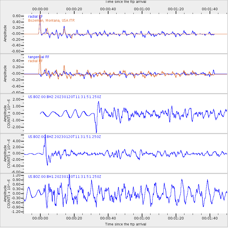
BOZ Bozeman, Montana, USA - Earthquake Result Viewer
*The percent match for this event was below the threshold and hence no stack was calculated.
| Earthquake location: |
Leeward Islands |
| Earthquake latitude/longitude: |
16.2/-62.0 |
| Earthquake time(UTC): |
2023/01/20 (020) 11:23:40 GMT |
| Earthquake Depth: |
165 km |
| Earthquake Magnitude: |
5.8 Mi |
| Earthquake Catalog/Contributor: |
NEIC PDE/pt |
|
| Network: |
US United States National Seismic Network |
| Station: |
BOZ Bozeman, Montana, USA |
| Lat/Lon: |
45.65 N/111.63 W |
| Elevation: |
1589 m |
|
| Distance: |
50.6 deg |
| Az: |
316.258 deg |
| Baz: |
108.768 deg |
| Ray Param: |
$rayparam |
*The percent match for this event was below the threshold and hence was not used in the summary stack. |
|
| Radial Match: |
77.14682 % |
| Radial Bump: |
267 |
| Transverse Match: |
50.833416 % |
| Transverse Bump: |
277 |
| SOD ConfigId: |
29823551 |
| Insert Time: |
2023-02-03 11:57:29.385 +0000 |
| GWidth: |
2.5 |
| Max Bumps: |
400 |
| Tol: |
0.001 |
|
Signal To Noise
| Channel | StoN | STA | LTA |
| US:BOZ:00:BHZ:20230120T11:31:51.250Z | 19.332111 | 2.2294155E-6 | 1.1532188E-7 |
| US:BOZ:00:BH1:20230120T11:31:51.250Z | 1.3127384 | 3.591406E-7 | 2.7358126E-7 |
| US:BOZ:00:BH2:20230120T11:31:51.250Z | 3.440526 | 1.0915907E-6 | 3.1727436E-7 |
| Arrivals |
| Ps | |
| PpPs | |
| PsPs/PpSs | |


