You are here: Home > Network List > US - United States National Seismic Network Stations List
> Station MIAR Mount Ida, Arkansas, USA > Earthquake Result Viewer
MIAR Mount Ida, Arkansas, USA - Earthquake Result Viewer
*The percent match for this event was below the threshold and hence no stack was calculated.
| Earthquake location: |
Leeward Islands |
| Earthquake latitude/longitude: |
16.2/-62.0 |
| Earthquake time(UTC): |
2023/01/20 (020) 11:23:40 GMT |
| Earthquake Depth: |
165 km |
| Earthquake Magnitude: |
5.8 Mi |
| Earthquake Catalog/Contributor: |
NEIC PDE/pt |
|
| Network: |
US United States National Seismic Network |
| Station: |
MIAR Mount Ida, Arkansas, USA |
| Lat/Lon: |
34.55 N/93.58 W |
| Elevation: |
207 m |
|
| Distance: |
33.6 deg |
| Az: |
308.751 deg |
| Baz: |
114.828 deg |
| Ray Param: |
$rayparam |
*The percent match for this event was below the threshold and hence was not used in the summary stack. |
|
| Radial Match: |
75.65988 % |
| Radial Bump: |
331 |
| Transverse Match: |
62.99496 % |
| Transverse Bump: |
400 |
| SOD ConfigId: |
29823551 |
| Insert Time: |
2023-02-03 11:57:59.764 +0000 |
| GWidth: |
2.5 |
| Max Bumps: |
400 |
| Tol: |
0.001 |
|
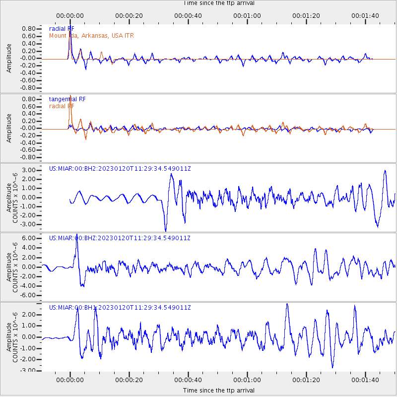
Signal To Noise
| Channel | StoN | STA | LTA |
| US:MIAR:00:BHZ:20230120T11:29:34.549011Z | 6.7797556 | 2.8916268E-6 | 4.26509E-7 |
| US:MIAR:00:BH1:20230120T11:29:34.549011Z | 7.0221524 | 1.2562172E-6 | 1.7889346E-7 |
| US:MIAR:00:BH2:20230120T11:29:34.549011Z | 5.1668134 | 1.7547175E-6 | 3.3961308E-7 |
| Arrivals |
| Ps | |
| PpPs | |
| PsPs/PpSs | |


