You are here: Home > Network List > US - United States National Seismic Network Stations List
> Station MSO Missoula, Montana, USA > Earthquake Result Viewer
MSO Missoula, Montana, USA - Earthquake Result Viewer
*The percent match for this event was below the threshold and hence no stack was calculated.
| Earthquake location: |
Leeward Islands |
| Earthquake latitude/longitude: |
16.2/-62.0 |
| Earthquake time(UTC): |
2023/01/20 (020) 11:23:40 GMT |
| Earthquake Depth: |
165 km |
| Earthquake Magnitude: |
5.8 Mi |
| Earthquake Catalog/Contributor: |
NEIC PDE/pt |
|
| Network: |
US United States National Seismic Network |
| Station: |
MSO Missoula, Montana, USA |
| Lat/Lon: |
46.83 N/113.94 W |
| Elevation: |
1264 m |
|
| Distance: |
52.5 deg |
| Az: |
317.053 deg |
| Baz: |
107.598 deg |
| Ray Param: |
$rayparam |
*The percent match for this event was below the threshold and hence was not used in the summary stack. |
|
| Radial Match: |
79.72231 % |
| Radial Bump: |
400 |
| Transverse Match: |
74.61478 % |
| Transverse Bump: |
400 |
| SOD ConfigId: |
29823551 |
| Insert Time: |
2023-02-03 11:58:02.853 +0000 |
| GWidth: |
2.5 |
| Max Bumps: |
400 |
| Tol: |
0.001 |
|
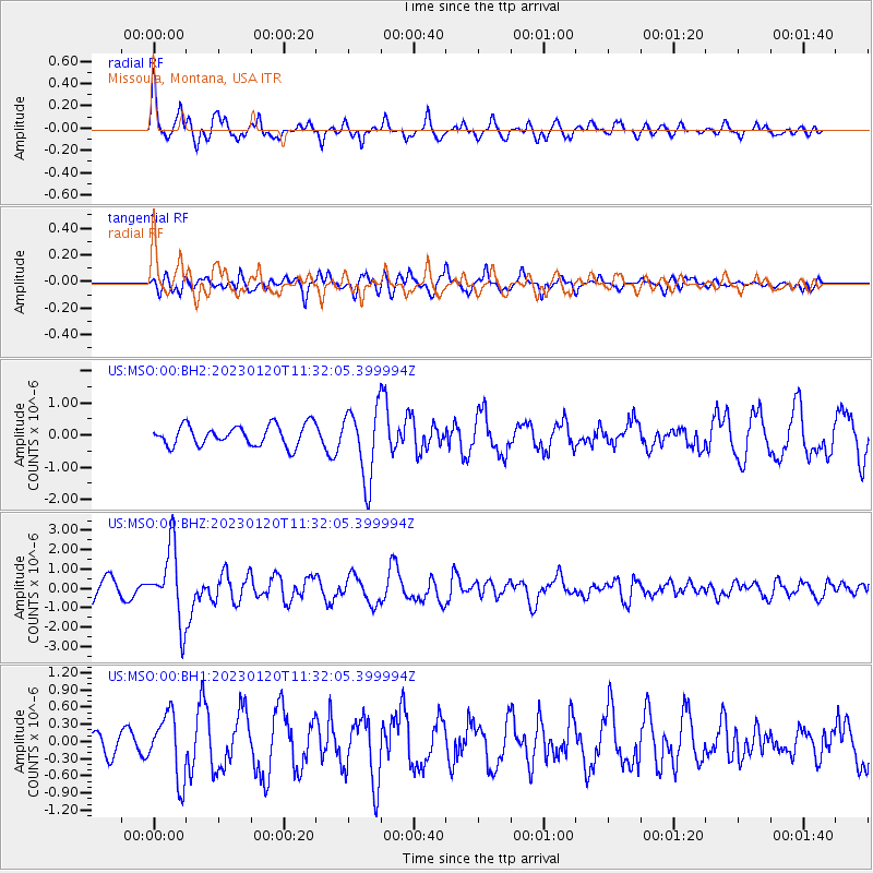
Signal To Noise
| Channel | StoN | STA | LTA |
| US:MSO:00:BHZ:20230120T11:32:05.399994Z | 3.8946428 | 1.8749871E-6 | 4.814272E-7 |
| US:MSO:00:BH1:20230120T11:32:05.399994Z | 3.1518688 | 5.557098E-7 | 1.763112E-7 |
| US:MSO:00:BH2:20230120T11:32:05.399994Z | 3.4615698 | 1.1077958E-6 | 3.20027E-7 |
| Arrivals |
| Ps | |
| PpPs | |
| PsPs/PpSs | |


