You are here: Home > Network List > UU - University of Utah Regional Network Stations List
> Station FORU South Mineral Mountains, UT, USA > Earthquake Result Viewer
FORU South Mineral Mountains, UT, USA - Earthquake Result Viewer
*The percent match for this event was below the threshold and hence no stack was calculated.
| Earthquake location: |
Leeward Islands |
| Earthquake latitude/longitude: |
16.2/-62.0 |
| Earthquake time(UTC): |
2023/01/20 (020) 11:23:40 GMT |
| Earthquake Depth: |
165 km |
| Earthquake Magnitude: |
5.8 Mi |
| Earthquake Catalog/Contributor: |
NEIC PDE/pt |
|
| Network: |
UU University of Utah Regional Network |
| Station: |
FORU South Mineral Mountains, UT, USA |
| Lat/Lon: |
38.46 N/112.86 W |
| Elevation: |
1840 m |
|
| Distance: |
49.6 deg |
| Az: |
306.907 deg |
| Baz: |
101.938 deg |
| Ray Param: |
$rayparam |
*The percent match for this event was below the threshold and hence was not used in the summary stack. |
|
| Radial Match: |
76.19146 % |
| Radial Bump: |
400 |
| Transverse Match: |
71.32943 % |
| Transverse Bump: |
400 |
| SOD ConfigId: |
29823551 |
| Insert Time: |
2023-02-03 11:58:39.428 +0000 |
| GWidth: |
2.5 |
| Max Bumps: |
400 |
| Tol: |
0.001 |
|
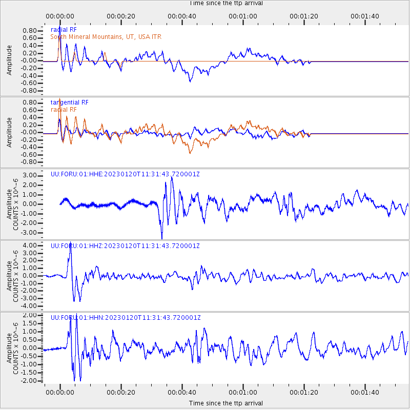
Signal To Noise
| Channel | StoN | STA | LTA |
| UU:FORU:01:HHZ:20230120T11:31:43.720001Z | 14.389465 | 1.7838885E-6 | 1.2397184E-7 |
| UU:FORU:01:HHN:20230120T11:31:43.720001Z | 2.9163146 | 8.0265113E-7 | 2.752279E-7 |
| UU:FORU:01:HHE:20230120T11:31:43.720001Z | 5.266888 | 1.296143E-6 | 2.4609272E-7 |
| Arrivals |
| Ps | |
| PpPs | |
| PsPs/PpSs | |


