You are here: Home > Network List > TA - USArray Transportable Network (new EarthScope stations) Stations List
> Station D21A La Casta Ranch, Jordon, MT, USA > Earthquake Result Viewer
D21A La Casta Ranch, Jordon, MT, USA - Earthquake Result Viewer
| Earthquake location: |
Near Coast Of Central Chile |
| Earthquake latitude/longitude: |
-34.3/-71.9 |
| Earthquake time(UTC): |
2010/03/11 (070) 14:39:43 GMT |
| Earthquake Depth: |
11 km |
| Earthquake Magnitude: |
6.7 MB, 7.0 MS, 6.9 MW, 6.9 MW |
| Earthquake Catalog/Contributor: |
WHDF/NEIC |
|
| Network: |
TA USArray Transportable Network (new EarthScope stations) |
| Station: |
D21A La Casta Ranch, Jordon, MT, USA |
| Lat/Lon: |
47.07 N/106.99 W |
| Elevation: |
934 m |
|
| Distance: |
86.9 deg |
| Az: |
336.817 deg |
| Baz: |
151.523 deg |
| Ray Param: |
0.0436991 |
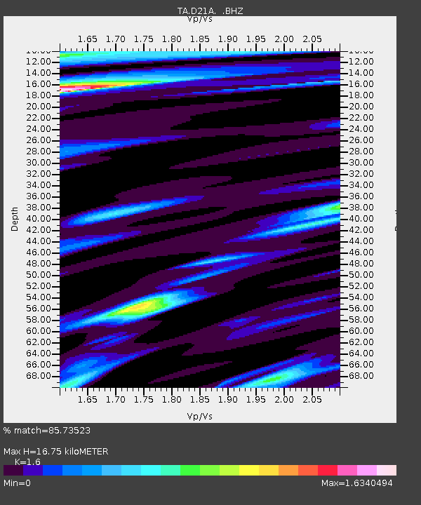
| Estimated Moho Depth: |
16.75 km |
| Estimated Crust Vp/Vs: |
1.60 |
| Assumed Crust Vp: |
6.438 km/s |
| Estimated Crust Vs: |
4.023 km/s |
| Estimated Crust Poisson's Ratio: |
0.18 |
|
| Radial Match: |
85.73523 % |
| Radial Bump: |
353 |
| Transverse Match: |
74.808945 % |
| Transverse Bump: |
400 |
| SOD ConfigId: |
299721 |
| Insert Time: |
2010-04-26 22:06:42.592 +0000 |
| GWidth: |
2.5 |
| Max Bumps: |
400 |
| Tol: |
0.001 |
|

Signal To Noise
| Channel | StoN | STA | LTA |
| TA:D21A: :BHZ:20100311T14:51:57.225024Z | 2.8340857 | 2.4718695E-6 | 8.7219297E-7 |
| TA:D21A: :BHN:20100311T14:51:57.225024Z | 0.9640559 | 1.3662986E-6 | 1.4172401E-6 |
| TA:D21A: :BHE:20100311T14:51:57.225024Z | 0.8422905 | 1.5550814E-6 | 1.846253E-6 |
| Arrivals |
| Ps | 1.6 SECOND |
| PpPs | 6.6 SECOND |
| PsPs/PpSs | 8.2 SECOND |


