You are here: Home > Network List > TA - USArray Transportable Network (new EarthScope stations) Stations List
> Station C20A Veseth Ranch, Zortman, MT, USA > Earthquake Result Viewer
C20A Veseth Ranch, Zortman, MT, USA - Earthquake Result Viewer
| Earthquake location: |
Near Coast Of Central Chile |
| Earthquake latitude/longitude: |
-34.3/-71.9 |
| Earthquake time(UTC): |
2010/03/11 (070) 14:39:43 GMT |
| Earthquake Depth: |
11 km |
| Earthquake Magnitude: |
6.7 MB, 7.0 MS, 6.9 MW, 6.9 MW |
| Earthquake Catalog/Contributor: |
WHDF/NEIC |
|
| Network: |
TA USArray Transportable Network (new EarthScope stations) |
| Station: |
C20A Veseth Ranch, Zortman, MT, USA |
| Lat/Lon: |
47.71 N/108.00 W |
| Elevation: |
781 m |
|
| Distance: |
87.8 deg |
| Az: |
336.528 deg |
| Baz: |
150.769 deg |
| Ray Param: |
0.043046176 |
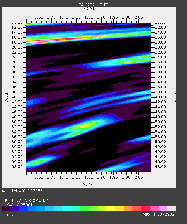
| Estimated Moho Depth: |
17.75 km |
| Estimated Crust Vp/Vs: |
1.61 |
| Assumed Crust Vp: |
6.518 km/s |
| Estimated Crust Vs: |
4.042 km/s |
| Estimated Crust Poisson's Ratio: |
0.19 |
|
| Radial Match: |
81.137856 % |
| Radial Bump: |
400 |
| Transverse Match: |
71.463264 % |
| Transverse Bump: |
400 |
| SOD ConfigId: |
299721 |
| Insert Time: |
2010-04-26 22:06:57.480 +0000 |
| GWidth: |
2.5 |
| Max Bumps: |
400 |
| Tol: |
0.001 |
|

Signal To Noise
| Channel | StoN | STA | LTA |
| TA:C20A: :BHZ:20100311T14:52:01.549976Z | 5.704242 | 2.5691236E-6 | 4.5038823E-7 |
| TA:C20A: :BHN:20100311T14:52:01.549976Z | 1.3593862 | 1.7389939E-6 | 1.2792493E-6 |
| TA:C20A: :BHE:20100311T14:52:01.549976Z | 1.4625106 | 1.375517E-6 | 9.405176E-7 |
| Arrivals |
| Ps | 1.7 SECOND |
| PpPs | 6.9 SECOND |
| PsPs/PpSs | 8.6 SECOND |


