You are here: Home > Network List > UW - Pacific Northwest Regional Seismic Network Stations List
> Station IRON Crane, OR, USA > Earthquake Result Viewer
IRON Crane, OR, USA - Earthquake Result Viewer
*The percent match for this event was below the threshold and hence no stack was calculated.
| Earthquake location: |
Leeward Islands |
| Earthquake latitude/longitude: |
16.2/-62.0 |
| Earthquake time(UTC): |
2023/01/20 (020) 11:23:40 GMT |
| Earthquake Depth: |
165 km |
| Earthquake Magnitude: |
5.8 Mi |
| Earthquake Catalog/Contributor: |
NEIC PDE/pt |
|
| Network: |
UW Pacific Northwest Regional Seismic Network |
| Station: |
IRON Crane, OR, USA |
| Lat/Lon: |
43.36 N/118.47 W |
| Elevation: |
1226 m |
|
| Distance: |
54.7 deg |
| Az: |
311.884 deg |
| Baz: |
101.328 deg |
| Ray Param: |
$rayparam |
*The percent match for this event was below the threshold and hence was not used in the summary stack. |
|
| Radial Match: |
78.08805 % |
| Radial Bump: |
400 |
| Transverse Match: |
65.10126 % |
| Transverse Bump: |
360 |
| SOD ConfigId: |
29823551 |
| Insert Time: |
2023-02-03 12:00:31.948 +0000 |
| GWidth: |
2.5 |
| Max Bumps: |
400 |
| Tol: |
0.001 |
|
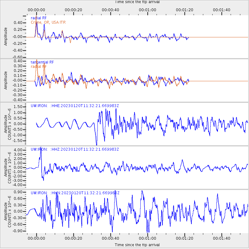
Signal To Noise
| Channel | StoN | STA | LTA |
| UW:IRON: :HHZ:20230120T11:32:21.669983Z | 10.015058 | 1.7786676E-6 | 1.7759935E-7 |
| UW:IRON: :HHN:20230120T11:32:21.669983Z | 0.7536401 | 2.0531793E-7 | 2.72435E-7 |
| UW:IRON: :HHE:20230120T11:32:21.669983Z | 2.906711 | 7.212239E-7 | 2.4812368E-7 |
| Arrivals |
| Ps | |
| PpPs | |
| PsPs/PpSs | |


