You are here: Home > Network List > UW - Pacific Northwest Regional Seismic Network Stations List
> Station LCCR Clarks, OR, USA > Earthquake Result Viewer
LCCR Clarks, OR, USA - Earthquake Result Viewer
*The percent match for this event was below the threshold and hence no stack was calculated.
| Earthquake location: |
Leeward Islands |
| Earthquake latitude/longitude: |
16.2/-62.0 |
| Earthquake time(UTC): |
2023/01/20 (020) 11:23:40 GMT |
| Earthquake Depth: |
165 km |
| Earthquake Magnitude: |
5.8 Mi |
| Earthquake Catalog/Contributor: |
NEIC PDE/pt |
|
| Network: |
UW Pacific Northwest Regional Seismic Network |
| Station: |
LCCR Clarks, OR, USA |
| Lat/Lon: |
45.21 N/122.48 W |
| Elevation: |
271 m |
|
| Distance: |
57.9 deg |
| Az: |
313.445 deg |
| Baz: |
99.407 deg |
| Ray Param: |
$rayparam |
*The percent match for this event was below the threshold and hence was not used in the summary stack. |
|
| Radial Match: |
60.610806 % |
| Radial Bump: |
400 |
| Transverse Match: |
57.28309 % |
| Transverse Bump: |
400 |
| SOD ConfigId: |
29823551 |
| Insert Time: |
2023-02-03 12:00:44.288 +0000 |
| GWidth: |
2.5 |
| Max Bumps: |
400 |
| Tol: |
0.001 |
|
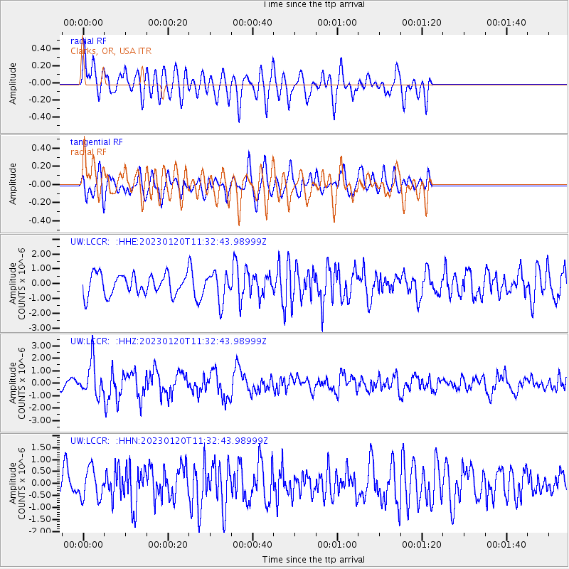
Signal To Noise
| Channel | StoN | STA | LTA |
| UW:LCCR: :HHZ:20230120T11:32:43.98999Z | 2.7890837 | 1.3458513E-6 | 4.825425E-7 |
| UW:LCCR: :HHN:20230120T11:32:43.98999Z | 1.0084414 | 6.3422E-7 | 6.2891104E-7 |
| UW:LCCR: :HHE:20230120T11:32:43.98999Z | 1.4385377 | 9.898246E-7 | 6.880769E-7 |
| Arrivals |
| Ps | |
| PpPs | |
| PsPs/PpSs | |


