You are here: Home > Network List > UW - Pacific Northwest Regional Seismic Network Stations List
> Station RCM Mt. Rainier, Camp Muir > Earthquake Result Viewer
RCM Mt. Rainier, Camp Muir - Earthquake Result Viewer
| Earthquake location: |
Leeward Islands |
| Earthquake latitude/longitude: |
16.2/-62.0 |
| Earthquake time(UTC): |
2023/01/20 (020) 11:23:40 GMT |
| Earthquake Depth: |
165 km |
| Earthquake Magnitude: |
5.8 Mi |
| Earthquake Catalog/Contributor: |
NEIC PDE/pt |
|
| Network: |
UW Pacific Northwest Regional Seismic Network |
| Station: |
RCM Mt. Rainier, Camp Muir |
| Lat/Lon: |
46.84 N/121.73 W |
| Elevation: |
3085 m |
|
| Distance: |
57.7 deg |
| Az: |
315.45 deg |
| Baz: |
101.01 deg |
| Ray Param: |
0.06279986 |
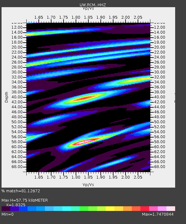
| Estimated Moho Depth: |
57.75 km |
| Estimated Crust Vp/Vs: |
1.83 |
| Assumed Crust Vp: |
6.597 km/s |
| Estimated Crust Vs: |
3.6 km/s |
| Estimated Crust Poisson's Ratio: |
0.29 |
|
| Radial Match: |
81.12672 % |
| Radial Bump: |
400 |
| Transverse Match: |
57.400074 % |
| Transverse Bump: |
400 |
| SOD ConfigId: |
29823551 |
| Insert Time: |
2023-02-03 12:01:46.272 +0000 |
| GWidth: |
2.5 |
| Max Bumps: |
400 |
| Tol: |
0.001 |
|

Signal To Noise
| Channel | StoN | STA | LTA |
| UW:RCM: :HHZ:20230120T11:32:42.440002Z | 7.419371 | 1.7800138E-6 | 2.3991439E-7 |
| UW:RCM: :HHN:20230120T11:32:42.440002Z | 1.27305 | 4.5054247E-7 | 3.5390792E-7 |
| UW:RCM: :HHE:20230120T11:32:42.440002Z | 2.7784283 | 9.239731E-7 | 3.3255245E-7 |
| Arrivals |
| Ps | 7.7 SECOND |
| PpPs | 24 SECOND |
| PsPs/PpSs | 31 SECOND |


