You are here: Home > Network List > TA - USArray Transportable Network (new EarthScope stations) Stations List
> Station A21A Bergtoll Ranch, Theony, MT, USA > Earthquake Result Viewer
A21A Bergtoll Ranch, Theony, MT, USA - Earthquake Result Viewer
| Earthquake location: |
Near Coast Of Central Chile |
| Earthquake latitude/longitude: |
-34.3/-71.9 |
| Earthquake time(UTC): |
2010/03/11 (070) 14:39:43 GMT |
| Earthquake Depth: |
11 km |
| Earthquake Magnitude: |
6.7 MB, 7.0 MS, 6.9 MW, 6.9 MW |
| Earthquake Catalog/Contributor: |
WHDF/NEIC |
|
| Network: |
TA USArray Transportable Network (new EarthScope stations) |
| Station: |
A21A Bergtoll Ranch, Theony, MT, USA |
| Lat/Lon: |
48.99 N/106.93 W |
| Elevation: |
779 m |
|
| Distance: |
88.6 deg |
| Az: |
337.775 deg |
| Baz: |
151.612 deg |
| Ray Param: |
0.042470887 |
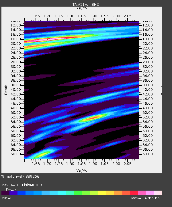
| Estimated Moho Depth: |
18.0 km |
| Estimated Crust Vp/Vs: |
1.70 |
| Assumed Crust Vp: |
6.438 km/s |
| Estimated Crust Vs: |
3.787 km/s |
| Estimated Crust Poisson's Ratio: |
0.24 |
|
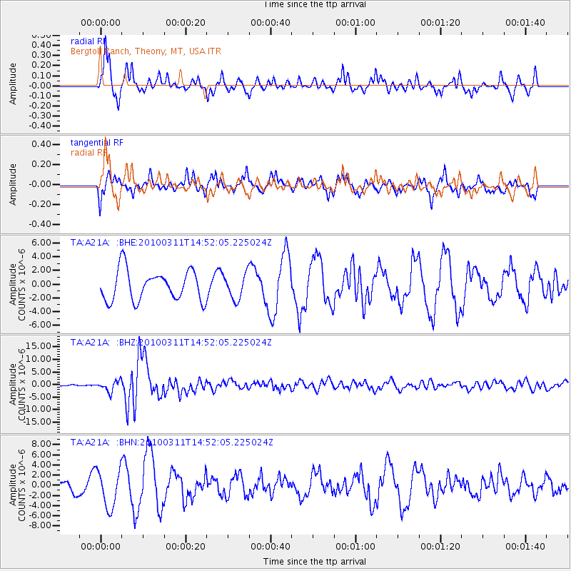
| Radial Match: |
87.389206 % |
| Radial Bump: |
336 |
| Transverse Match: |
56.782463 % |
| Transverse Bump: |
400 |
| SOD ConfigId: |
299721 |
| Insert Time: |
2010-04-26 22:08:50.620 +0000 |
| GWidth: |
2.5 |
| Max Bumps: |
400 |
| Tol: |
0.001 |
|
Signal To Noise
| Channel | StoN | STA | LTA |
| TA:A21A: :BHZ:20100311T14:52:05.225024Z | 2.2161152 | 2.1716169E-6 | 9.799205E-7 |
| TA:A21A: :BHN:20100311T14:52:05.225024Z | 3.135949 | 3.7580967E-6 | 1.1983923E-6 |
| TA:A21A: :BHE:20100311T14:52:05.225024Z | 0.8461706 | 1.8642531E-6 | 2.2031645E-6 |
| Arrivals |
| Ps | 2.0 SECOND |
| PpPs | 7.4 SECOND |
| PsPs/PpSs | 9.4 SECOND |


