You are here: Home > Network List > AG - Arkansas Seismic Network Stations List
> Station XA02 Annieville, Arkansas > Earthquake Result Viewer
XA02 Annieville, Arkansas - Earthquake Result Viewer
| Earthquake location: |
Santiago Del Estero Prov., Arg. |
| Earthquake latitude/longitude: |
-26.7/-63.0 |
| Earthquake time(UTC): |
2023/01/20 (020) 22:09:39 GMT |
| Earthquake Depth: |
611 km |
| Earthquake Magnitude: |
6.8 mww |
| Earthquake Catalog/Contributor: |
NEIC PDE/us |
|
| Network: |
AG Arkansas Seismic Network |
| Station: |
XA02 Annieville, Arkansas |
| Lat/Lon: |
36.16 N/91.26 W |
| Elevation: |
190 m |
|
| Distance: |
68.0 deg |
| Az: |
335.622 deg |
| Baz: |
152.858 deg |
| Ray Param: |
0.054409526 |
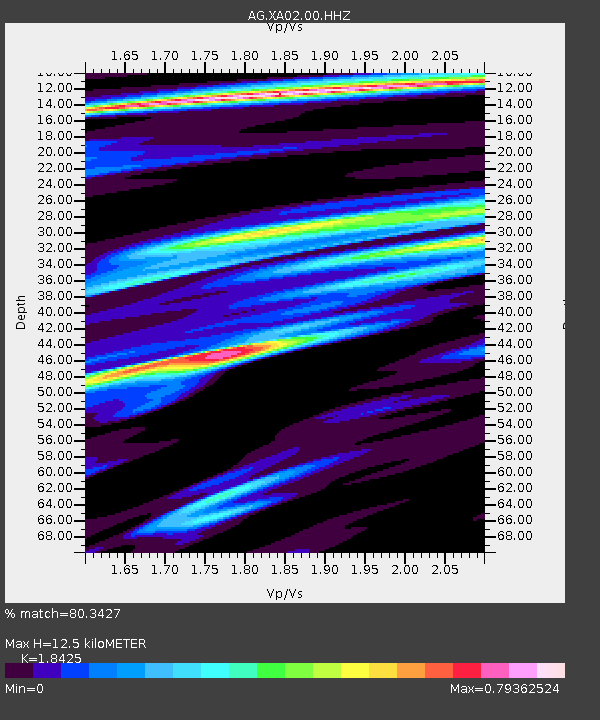
| Estimated Moho Depth: |
12.5 km |
| Estimated Crust Vp/Vs: |
1.84 |
| Assumed Crust Vp: |
6.53 km/s |
| Estimated Crust Vs: |
3.544 km/s |
| Estimated Crust Poisson's Ratio: |
0.29 |
|
| Radial Match: |
80.3427 % |
| Radial Bump: |
400 |
| Transverse Match: |
52.10369 % |
| Transverse Bump: |
400 |
| SOD ConfigId: |
29823551 |
| Insert Time: |
2023-02-03 22:11:00.741 +0000 |
| GWidth: |
2.5 |
| Max Bumps: |
400 |
| Tol: |
0.001 |
|

Signal To Noise
| Channel | StoN | STA | LTA |
| AG:XA02:00:HHZ:20230120T22:19:08.399977Z | 24.276049 | 8.06066E-6 | 3.3204168E-7 |
| AG:XA02:00:HHN:20230120T22:19:08.399977Z | 9.062908 | 4.215337E-6 | 4.6511965E-7 |
| AG:XA02:00:HHE:20230120T22:19:08.399977Z | 6.907486 | 3.8980693E-6 | 5.643253E-7 |
| Arrivals |
| Ps | 1.7 SECOND |
| PpPs | 5.2 SECOND |
| PsPs/PpSs | 6.9 SECOND |


