You are here: Home > Network List > AG - Arkansas Seismic Network Stations List
> Station XB03 El Dorado Temporary Station XB03 > Earthquake Result Viewer
XB03 El Dorado Temporary Station XB03 - Earthquake Result Viewer
| Earthquake location: |
Santiago Del Estero Prov., Arg. |
| Earthquake latitude/longitude: |
-26.7/-63.0 |
| Earthquake time(UTC): |
2023/01/20 (020) 22:09:39 GMT |
| Earthquake Depth: |
611 km |
| Earthquake Magnitude: |
6.8 mww |
| Earthquake Catalog/Contributor: |
NEIC PDE/us |
|
| Network: |
AG Arkansas Seismic Network |
| Station: |
XB03 El Dorado Temporary Station XB03 |
| Lat/Lon: |
36.48 N/90.87 W |
| Elevation: |
144 m |
|
| Distance: |
68.1 deg |
| Az: |
336.08 deg |
| Baz: |
153.259 deg |
| Ray Param: |
0.05432584 |
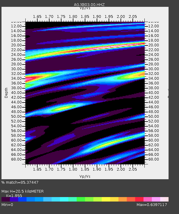
| Estimated Moho Depth: |
20.5 km |
| Estimated Crust Vp/Vs: |
1.96 |
| Assumed Crust Vp: |
6.53 km/s |
| Estimated Crust Vs: |
3.34 km/s |
| Estimated Crust Poisson's Ratio: |
0.32 |
|
| Radial Match: |
85.37447 % |
| Radial Bump: |
395 |
| Transverse Match: |
56.565918 % |
| Transverse Bump: |
400 |
| SOD ConfigId: |
29823551 |
| Insert Time: |
2023-02-03 22:11:03.847 +0000 |
| GWidth: |
2.5 |
| Max Bumps: |
400 |
| Tol: |
0.001 |
|

Signal To Noise
| Channel | StoN | STA | LTA |
| AG:XB03:00:HHZ:20230120T22:19:09.250013Z | 35.312675 | 1.6864256E-5 | 4.7756953E-7 |
| AG:XB03:00:HHN:20230120T22:19:09.250013Z | 24.087818 | 1.0165004E-5 | 4.219977E-7 |
| AG:XB03:00:HHE:20230120T22:19:09.250013Z | 8.610475 | 6.5818267E-6 | 7.643976E-7 |
| Arrivals |
| Ps | 3.1 SECOND |
| PpPs | 9.0 SECOND |
| PsPs/PpSs | 12 SECOND |


