You are here: Home > Network List > TA - USArray Transportable Network (new EarthScope stations) Stations List
> Station I23A Meade Ranch, Gillette, WY, USA > Earthquake Result Viewer
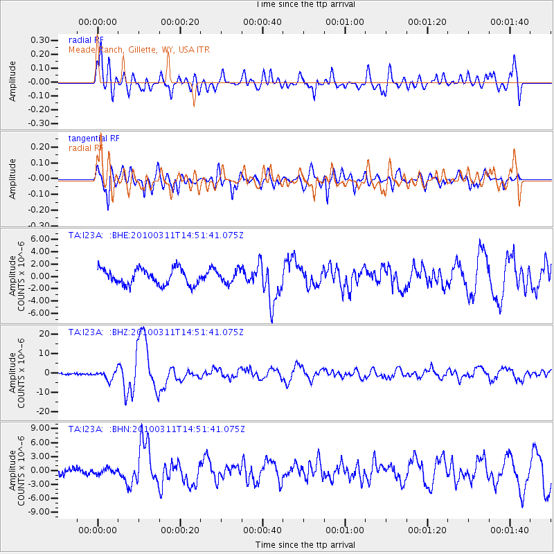
I23A Meade Ranch, Gillette, WY, USA - Earthquake Result Viewer
*The percent match for this event was below the threshold and hence no stack was calculated.
| Earthquake location: |
Near Coast Of Central Chile |
| Earthquake latitude/longitude: |
-34.3/-71.9 |
| Earthquake time(UTC): |
2010/03/11 (070) 14:39:43 GMT |
| Earthquake Depth: |
11 km |
| Earthquake Magnitude: |
6.7 MB, 7.0 MS, 6.9 MW, 6.9 MW |
| Earthquake Catalog/Contributor: |
WHDF/NEIC |
|
| Network: |
TA USArray Transportable Network (new EarthScope stations) |
| Station: |
I23A Meade Ranch, Gillette, WY, USA |
| Lat/Lon: |
43.96 N/105.46 W |
| Elevation: |
1462 m |
|
| Distance: |
83.7 deg |
| Az: |
336.31 deg |
| Baz: |
152.571 deg |
| Ray Param: |
$rayparam |
*The percent match for this event was below the threshold and hence was not used in the summary stack. |
|
| Radial Match: |
78.20818 % |
| Radial Bump: |
400 |
| Transverse Match: |
82.66308 % |
| Transverse Bump: |
400 |
| SOD ConfigId: |
299721 |
| Insert Time: |
2010-04-26 22:10:04.349 +0000 |
| GWidth: |
2.5 |
| Max Bumps: |
400 |
| Tol: |
0.001 |
|
Signal To Noise
| Channel | StoN | STA | LTA |
| TA:I23A: :BHZ:20100311T14:51:41.075Z | 5.176423 | 2.4392932E-6 | 4.7123143E-7 |
| TA:I23A: :BHN:20100311T14:51:41.075Z | 0.76277345 | 5.703303E-7 | 7.4770605E-7 |
| TA:I23A: :BHE:20100311T14:51:41.075Z | 0.79903644 | 1.0116254E-6 | 1.2660566E-6 |
| Arrivals |
| Ps | |
| PpPs | |
| PsPs/PpSs | |


