You are here: Home > Network List > TA - USArray Transportable Network (new EarthScope stations) Stations List
> Station R23A Moffat, CO, USA > Earthquake Result Viewer
R23A Moffat, CO, USA - Earthquake Result Viewer
| Earthquake location: |
Near Coast Of Central Chile |
| Earthquake latitude/longitude: |
-34.3/-71.9 |
| Earthquake time(UTC): |
2010/03/11 (070) 14:39:43 GMT |
| Earthquake Depth: |
11 km |
| Earthquake Magnitude: |
6.7 MB, 7.0 MS, 6.9 MW, 6.9 MW |
| Earthquake Catalog/Contributor: |
WHDF/NEIC |
|
| Network: |
TA USArray Transportable Network (new EarthScope stations) |
| Station: |
R23A Moffat, CO, USA |
| Lat/Lon: |
38.19 N/105.83 W |
| Elevation: |
2547 m |
|
| Distance: |
78.7 deg |
| Az: |
333.347 deg |
| Baz: |
151.878 deg |
| Ray Param: |
0.049463216 |
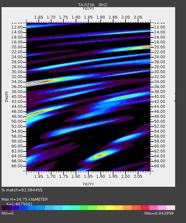
| Estimated Moho Depth: |
34.75 km |
| Estimated Crust Vp/Vs: |
1.61 |
| Assumed Crust Vp: |
6.159 km/s |
| Estimated Crust Vs: |
3.831 km/s |
| Estimated Crust Poisson's Ratio: |
0.18 |
|
| Radial Match: |
92.894455 % |
| Radial Bump: |
400 |
| Transverse Match: |
90.30626 % |
| Transverse Bump: |
400 |
| SOD ConfigId: |
299721 |
| Insert Time: |
2010-04-26 22:10:43.013 +0000 |
| GWidth: |
2.5 |
| Max Bumps: |
400 |
| Tol: |
0.001 |
|
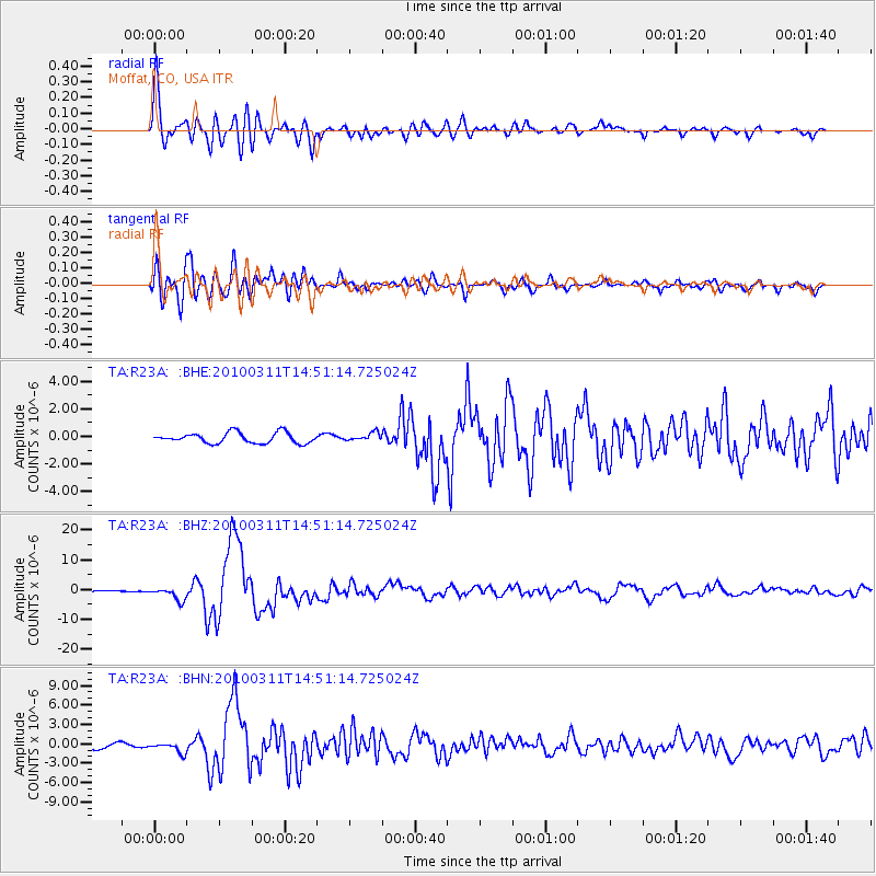
Signal To Noise
| Channel | StoN | STA | LTA |
| TA:R23A: :BHZ:20100311T14:51:14.725024Z | 10.533584 | 2.1545761E-6 | 2.0454351E-7 |
| TA:R23A: :BHN:20100311T14:51:14.725024Z | 1.8602866 | 8.054055E-7 | 4.32947E-7 |
| TA:R23A: :BHE:20100311T14:51:14.725024Z | 0.77898335 | 2.93344E-7 | 3.7657287E-7 |
| Arrivals |
| Ps | 3.5 SECOND |
| PpPs | 14 SECOND |
| PsPs/PpSs | 18 SECOND |


