You are here: Home > Network List > TA - USArray Transportable Network (new EarthScope stations) Stations List
> Station G23A Biddle, MT, USA > Earthquake Result Viewer
G23A Biddle, MT, USA - Earthquake Result Viewer
| Earthquake location: |
Near Coast Of Central Chile |
| Earthquake latitude/longitude: |
-34.3/-71.9 |
| Earthquake time(UTC): |
2010/03/11 (070) 14:39:43 GMT |
| Earthquake Depth: |
11 km |
| Earthquake Magnitude: |
6.7 MB, 7.0 MS, 6.9 MW, 6.9 MW |
| Earthquake Catalog/Contributor: |
WHDF/NEIC |
|
| Network: |
TA USArray Transportable Network (new EarthScope stations) |
| Station: |
G23A Biddle, MT, USA |
| Lat/Lon: |
45.20 N/105.39 W |
| Elevation: |
1064 m |
|
| Distance: |
84.7 deg |
| Az: |
336.93 deg |
| Baz: |
152.684 deg |
| Ray Param: |
0.045257855 |
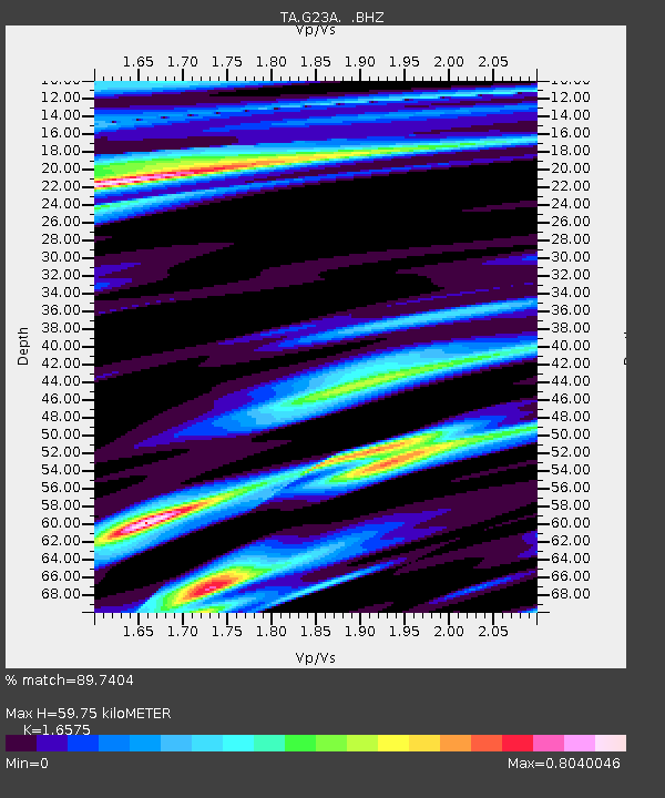
| Estimated Moho Depth: |
59.75 km |
| Estimated Crust Vp/Vs: |
1.66 |
| Assumed Crust Vp: |
6.242 km/s |
| Estimated Crust Vs: |
3.766 km/s |
| Estimated Crust Poisson's Ratio: |
0.21 |
|
| Radial Match: |
89.7404 % |
| Radial Bump: |
400 |
| Transverse Match: |
75.75053 % |
| Transverse Bump: |
400 |
| SOD ConfigId: |
299721 |
| Insert Time: |
2010-04-26 22:12:29.229 +0000 |
| GWidth: |
2.5 |
| Max Bumps: |
400 |
| Tol: |
0.001 |
|
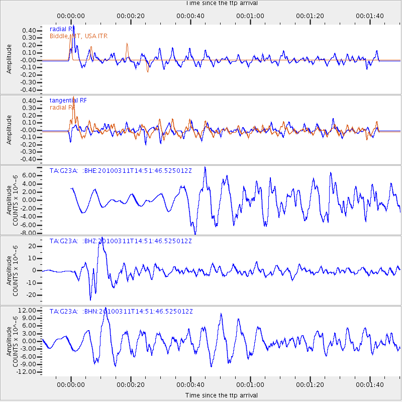
Signal To Noise
| Channel | StoN | STA | LTA |
| TA:G23A: :BHZ:20100311T14:51:46.525012Z | 8.223458 | 3.3833135E-6 | 4.1142223E-7 |
| TA:G23A: :BHN:20100311T14:51:46.525012Z | 2.199385 | 2.365988E-6 | 1.0757498E-6 |
| TA:G23A: :BHE:20100311T14:51:46.525012Z | 1.1026559 | 1.5733086E-6 | 1.4268355E-6 |
| Arrivals |
| Ps | 6.5 SECOND |
| PpPs | 25 SECOND |
| PsPs/PpSs | 31 SECOND |


