You are here: Home > Network List > TA - USArray Transportable Network (new EarthScope stations) Stations List
> Station N27A Anderson Farm, Haxtun, CO, USA > Earthquake Result Viewer
N27A Anderson Farm, Haxtun, CO, USA - Earthquake Result Viewer
| Earthquake location: |
Near Coast Of Central Chile |
| Earthquake latitude/longitude: |
-34.3/-71.9 |
| Earthquake time(UTC): |
2010/03/11 (070) 14:39:43 GMT |
| Earthquake Depth: |
11 km |
| Earthquake Magnitude: |
6.7 MB, 7.0 MS, 6.9 MW, 6.9 MW |
| Earthquake Catalog/Contributor: |
WHDF/NEIC |
|
| Network: |
TA USArray Transportable Network (new EarthScope stations) |
| Station: |
N27A Anderson Farm, Haxtun, CO, USA |
| Lat/Lon: |
40.81 N/102.54 W |
| Elevation: |
1228 m |
|
| Distance: |
79.9 deg |
| Az: |
336.856 deg |
| Baz: |
154.615 deg |
| Ray Param: |
0.04865333 |
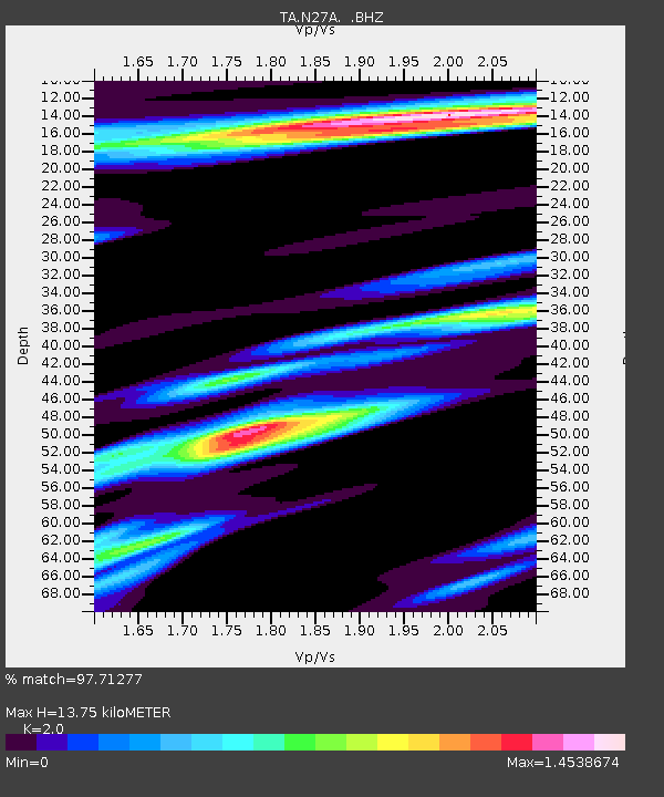
| Estimated Moho Depth: |
13.75 km |
| Estimated Crust Vp/Vs: |
2.00 |
| Assumed Crust Vp: |
6.483 km/s |
| Estimated Crust Vs: |
3.241 km/s |
| Estimated Crust Poisson's Ratio: |
0.33 |
|
| Radial Match: |
97.71277 % |
| Radial Bump: |
388 |
| Transverse Match: |
88.82374 % |
| Transverse Bump: |
400 |
| SOD ConfigId: |
299721 |
| Insert Time: |
2010-04-26 22:13:02.441 +0000 |
| GWidth: |
2.5 |
| Max Bumps: |
400 |
| Tol: |
0.001 |
|
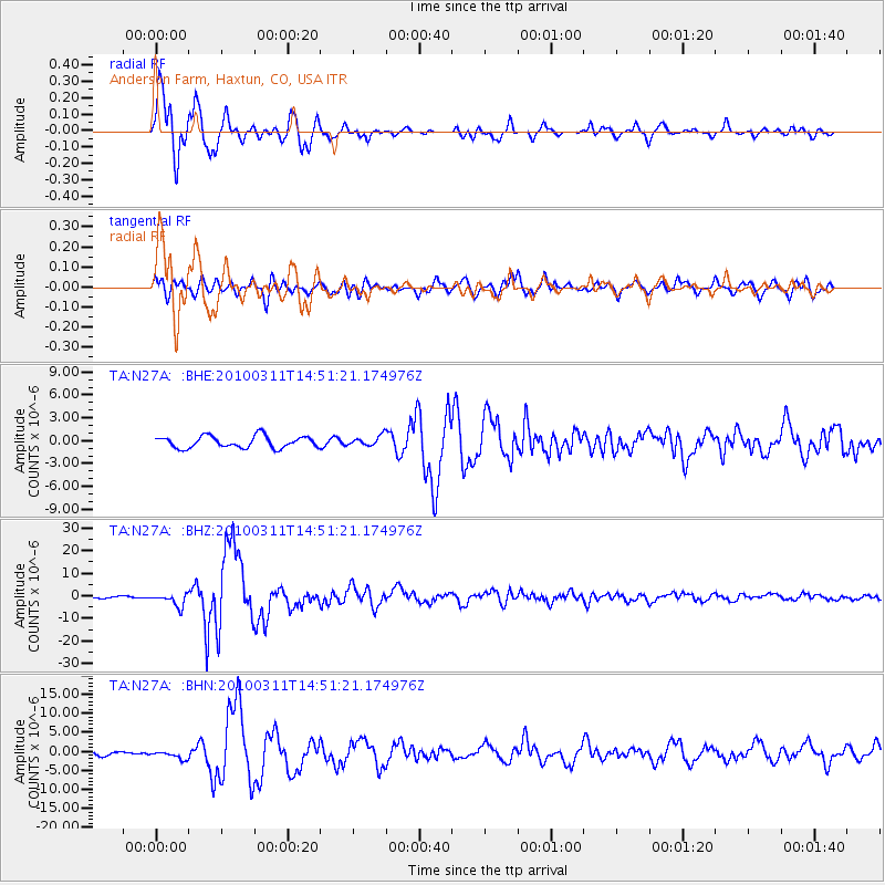
Signal To Noise
| Channel | StoN | STA | LTA |
| TA:N27A: :BHZ:20100311T14:51:21.174976Z | 10.403437 | 2.8511538E-6 | 2.7405883E-7 |
| TA:N27A: :BHN:20100311T14:51:21.174976Z | 1.7714056 | 1.0206878E-6 | 5.7620224E-7 |
| TA:N27A: :BHE:20100311T14:51:21.174976Z | 0.849599 | 6.5032435E-7 | 7.654486E-7 |
| Arrivals |
| Ps | 2.2 SECOND |
| PpPs | 6.2 SECOND |
| PsPs/PpSs | 8.4 SECOND |


