You are here: Home > Network List > MB - Montana Regional Seismic Network Stations List
> Station SRMT Salmond Ranch > Earthquake Result Viewer
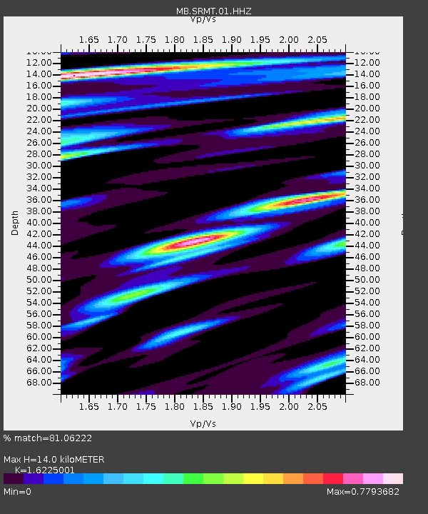
SRMT Salmond Ranch - Earthquake Result Viewer
| Earthquake location: |
Santiago Del Estero Prov., Arg. |
| Earthquake latitude/longitude: |
-26.7/-63.0 |
| Earthquake time(UTC): |
2023/01/20 (020) 22:09:39 GMT |
| Earthquake Depth: |
611 km |
| Earthquake Magnitude: |
6.8 mww |
| Earthquake Catalog/Contributor: |
NEIC PDE/us |
|
| Network: |
MB Montana Regional Seismic Network |
| Station: |
SRMT Salmond Ranch |
| Lat/Lon: |
47.78 N/112.61 W |
| Elevation: |
1522 m |
|
| Distance: |
86.5 deg |
| Az: |
329.044 deg |
| Baz: |
136.994 deg |
| Ray Param: |
0.042229936 |
| Estimated Moho Depth: |
14.0 km |
| Estimated Crust Vp/Vs: |
1.62 |
| Assumed Crust Vp: |
6.353 km/s |
| Estimated Crust Vs: |
3.916 km/s |
| Estimated Crust Poisson's Ratio: |
0.19 |
|
| Radial Match: |
81.06222 % |
| Radial Bump: |
392 |
| Transverse Match: |
69.46222 % |
| Transverse Bump: |
400 |
| SOD ConfigId: |
29823551 |
| Insert Time: |
2023-02-03 22:23:22.734 +0000 |
| GWidth: |
2.5 |
| Max Bumps: |
400 |
| Tol: |
0.001 |
|

Signal To Noise
| Channel | StoN | STA | LTA |
| MB:SRMT:01:HHZ:20230120T22:20:47.899977Z | 9.4402275 | 4.644804E-6 | 4.920225E-7 |
| MB:SRMT:01:HHN:20230120T22:20:47.899977Z | 1.9826254 | 8.2721016E-7 | 4.172297E-7 |
| MB:SRMT:01:HHE:20230120T22:20:47.899977Z | 3.689869 | 2.0166615E-6 | 5.4654015E-7 |
| Arrivals |
| Ps | 1.4 SECOND |
| PpPs | 5.6 SECOND |
| PsPs/PpSs | 7.1 SECOND |


