You are here: Home > Network List > N4 - Central and EAstern US Network Stations List
> Station 250A Grady, AL, USA > Earthquake Result Viewer
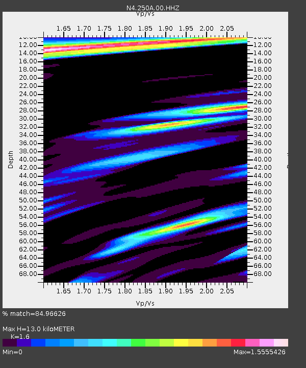
250A Grady, AL, USA - Earthquake Result Viewer
| Earthquake location: |
Santiago Del Estero Prov., Arg. |
| Earthquake latitude/longitude: |
-26.7/-63.0 |
| Earthquake time(UTC): |
2023/01/20 (020) 22:09:39 GMT |
| Earthquake Depth: |
611 km |
| Earthquake Magnitude: |
6.8 mww |
| Earthquake Catalog/Contributor: |
NEIC PDE/us |
|
| Network: |
N4 Central and EAstern US Network |
| Station: |
250A Grady, AL, USA |
| Lat/Lon: |
31.98 N/86.27 W |
| Elevation: |
152 m |
|
| Distance: |
62.4 deg |
| Az: |
337.784 deg |
| Baz: |
156.551 deg |
| Ray Param: |
0.057852905 |
| Estimated Moho Depth: |
13.0 km |
| Estimated Crust Vp/Vs: |
1.60 |
| Assumed Crust Vp: |
6.187 km/s |
| Estimated Crust Vs: |
3.867 km/s |
| Estimated Crust Poisson's Ratio: |
0.18 |
|
| Radial Match: |
84.96626 % |
| Radial Bump: |
400 |
| Transverse Match: |
68.9504 % |
| Transverse Bump: |
400 |
| SOD ConfigId: |
29823551 |
| Insert Time: |
2023-02-03 22:23:47.901 +0000 |
| GWidth: |
2.5 |
| Max Bumps: |
400 |
| Tol: |
0.001 |
|

Signal To Noise
| Channel | StoN | STA | LTA |
| N4:250A:00:HHZ:20230120T22:18:33.929029Z | 40.9784 | 1.020984E-5 | 2.4915173E-7 |
| N4:250A:00:HH1:20230120T22:18:33.929029Z | 4.7001834 | 3.580022E-6 | 7.6167703E-7 |
| N4:250A:00:HH2:20230120T22:18:33.929029Z | 2.8608723 | 2.2672316E-6 | 7.924967E-7 |
| Arrivals |
| Ps | 1.3 SECOND |
| PpPs | 5.2 SECOND |
| PsPs/PpSs | 6.6 SECOND |


