You are here: Home > Network List > TA - USArray Transportable Network (new EarthScope stations) Stations List
> Station V28A Channing, TX, USA > Earthquake Result Viewer
V28A Channing, TX, USA - Earthquake Result Viewer

| Earthquake location: |
Near Coast Of Central Chile |
| Earthquake latitude/longitude: |
-34.3/-71.9 |
| Earthquake time(UTC): |
2010/03/11 (070) 14:39:43 GMT |
| Earthquake Depth: |
11 km |
| Earthquake Magnitude: |
6.7 MB, 7.0 MS, 6.9 MW, 6.9 MW |
| Earthquake Catalog/Contributor: |
WHDF/NEIC |
|
| Network: |
TA USArray Transportable Network (new EarthScope stations) |
| Station: |
V28A Channing, TX, USA |
| Lat/Lon: |
35.75 N/102.22 W |
| Elevation: |
1163 m |
|
| Distance: |
75.2 deg |
| Az: |
334.858 deg |
| Baz: |
154.377 deg |
| Ray Param: |
0.051811673 |
| Estimated Moho Depth: |
44.25 km |
| Estimated Crust Vp/Vs: |
1.86 |
| Assumed Crust Vp: |
6.242 km/s |
| Estimated Crust Vs: |
3.36 km/s |
| Estimated Crust Poisson's Ratio: |
0.30 |
|
| Radial Match: |
98.28177 % |
| Radial Bump: |
372 |
| Transverse Match: |
91.94395 % |
| Transverse Bump: |
400 |
| SOD ConfigId: |
299721 |
| Insert Time: |
2010-04-26 22:14:26.008 +0000 |
| GWidth: |
2.5 |
| Max Bumps: |
400 |
| Tol: |
0.001 |
|
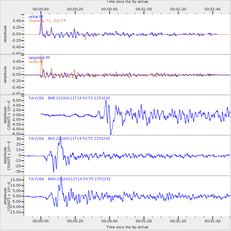
Signal To Noise
| Channel | StoN | STA | LTA |
| TA:V28A: :BHZ:20100311T14:50:55.225024Z | 18.9588 | 3.0743595E-6 | 1.6216002E-7 |
| TA:V28A: :BHN:20100311T14:50:55.225024Z | 3.8404653 | 1.0940881E-6 | 2.8488424E-7 |
| TA:V28A: :BHE:20100311T14:50:55.225024Z | 2.4353359 | 7.5656186E-7 | 3.1066017E-7 |
| Arrivals |
| Ps | 6.3 SECOND |
| PpPs | 20 SECOND |
| PsPs/PpSs | 26 SECOND |


