You are here: Home > Network List > TA - USArray Transportable Network (new EarthScope stations) Stations List
> Station W28A Vega, TX, USA > Earthquake Result Viewer
W28A Vega, TX, USA - Earthquake Result Viewer
| Earthquake location: |
Near Coast Of Central Chile |
| Earthquake latitude/longitude: |
-34.3/-71.9 |
| Earthquake time(UTC): |
2010/03/11 (070) 14:39:43 GMT |
| Earthquake Depth: |
11 km |
| Earthquake Magnitude: |
6.7 MB, 7.0 MS, 6.9 MW, 6.9 MW |
| Earthquake Catalog/Contributor: |
WHDF/NEIC |
|
| Network: |
TA USArray Transportable Network (new EarthScope stations) |
| Station: |
W28A Vega, TX, USA |
| Lat/Lon: |
35.26 N/102.21 W |
| Elevation: |
1156 m |
|
| Distance: |
74.8 deg |
| Az: |
334.652 deg |
| Baz: |
154.334 deg |
| Ray Param: |
0.052107066 |
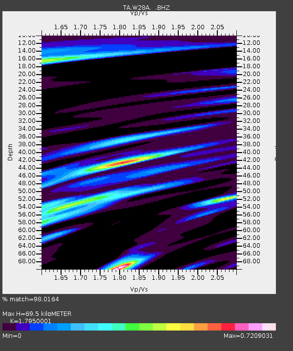
| Estimated Moho Depth: |
69.5 km |
| Estimated Crust Vp/Vs: |
1.80 |
| Assumed Crust Vp: |
6.242 km/s |
| Estimated Crust Vs: |
3.477 km/s |
| Estimated Crust Poisson's Ratio: |
0.27 |
|
| Radial Match: |
98.0164 % |
| Radial Bump: |
330 |
| Transverse Match: |
90.38595 % |
| Transverse Bump: |
400 |
| SOD ConfigId: |
299721 |
| Insert Time: |
2010-04-26 22:14:39.522 +0000 |
| GWidth: |
2.5 |
| Max Bumps: |
400 |
| Tol: |
0.001 |
|

Signal To Noise
| Channel | StoN | STA | LTA |
| TA:W28A: :BHZ:20100311T14:50:52.624988Z | 11.627229 | 3.179552E-6 | 2.7345743E-7 |
| TA:W28A: :BHN:20100311T14:50:52.624988Z | 8.493792 | 1.2987359E-6 | 1.5290414E-7 |
| TA:W28A: :BHE:20100311T14:50:52.624988Z | 2.7428179 | 5.703563E-7 | 2.0794538E-7 |
| Arrivals |
| Ps | 9.1 SECOND |
| PpPs | 30 SECOND |
| PsPs/PpSs | 39 SECOND |


