You are here: Home > Network List > TA - USArray Transportable Network (new EarthScope stations) Stations List
> Station 129A Stewart Farms, Lamesa, TX, USA > Earthquake Result Viewer
129A Stewart Farms, Lamesa, TX, USA - Earthquake Result Viewer
| Earthquake location: |
Near Coast Of Central Chile |
| Earthquake latitude/longitude: |
-34.3/-71.9 |
| Earthquake time(UTC): |
2010/03/11 (070) 14:39:43 GMT |
| Earthquake Depth: |
11 km |
| Earthquake Magnitude: |
6.7 MB, 7.0 MS, 6.9 MW, 6.9 MW |
| Earthquake Catalog/Contributor: |
WHDF/NEIC |
|
| Network: |
TA USArray Transportable Network (new EarthScope stations) |
| Station: |
129A Stewart Farms, Lamesa, TX, USA |
| Lat/Lon: |
32.63 N/101.87 W |
| Elevation: |
876 m |
|
| Distance: |
72.3 deg |
| Az: |
333.733 deg |
| Baz: |
154.263 deg |
| Ray Param: |
0.053757716 |
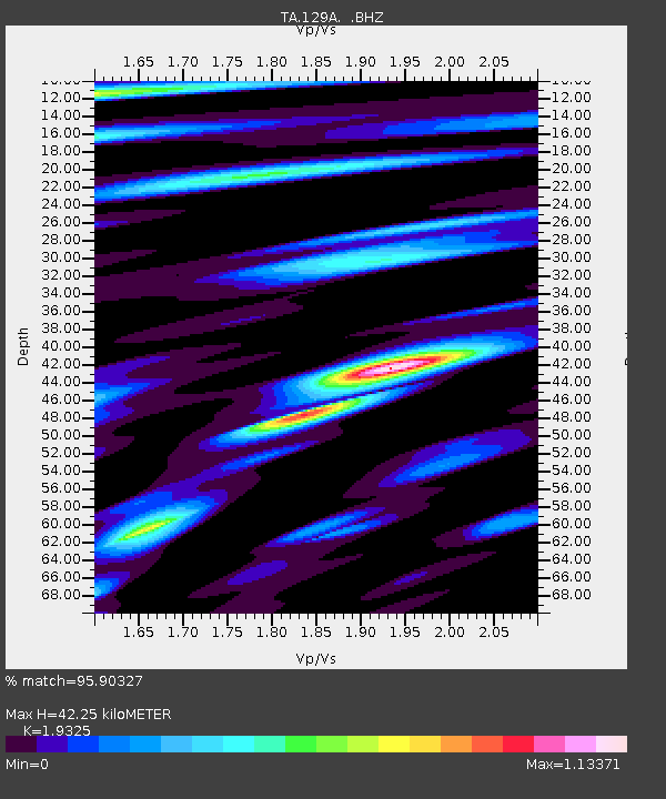
| Estimated Moho Depth: |
42.25 km |
| Estimated Crust Vp/Vs: |
1.93 |
| Assumed Crust Vp: |
6.426 km/s |
| Estimated Crust Vs: |
3.325 km/s |
| Estimated Crust Poisson's Ratio: |
0.32 |
|
| Radial Match: |
95.90327 % |
| Radial Bump: |
400 |
| Transverse Match: |
88.62736 % |
| Transverse Bump: |
400 |
| SOD ConfigId: |
299721 |
| Insert Time: |
2010-04-26 22:15:25.969 +0000 |
| GWidth: |
2.5 |
| Max Bumps: |
400 |
| Tol: |
0.001 |
|

Signal To Noise
| Channel | StoN | STA | LTA |
| TA:129A: :BHZ:20100311T14:50:38.049976Z | 16.030981 | 2.6700113E-6 | 1.6655322E-7 |
| TA:129A: :BHN:20100311T14:50:38.049976Z | 3.9700737 | 8.66558E-7 | 2.1827253E-7 |
| TA:129A: :BHE:20100311T14:50:38.049976Z | 2.6839519 | 7.7063515E-7 | 2.8712705E-7 |
| Arrivals |
| Ps | 6.3 SECOND |
| PpPs | 19 SECOND |
| PsPs/PpSs | 25 SECOND |


