You are here: Home > Network List > TA - USArray Transportable Network (new EarthScope stations) Stations List
> Station ABTX Abilene, Hawley, TX, USA > Earthquake Result Viewer
ABTX Abilene, Hawley, TX, USA - Earthquake Result Viewer
| Earthquake location: |
Near Coast Of Central Chile |
| Earthquake latitude/longitude: |
-34.3/-71.9 |
| Earthquake time(UTC): |
2010/03/11 (070) 14:39:43 GMT |
| Earthquake Depth: |
11 km |
| Earthquake Magnitude: |
6.7 MB, 7.0 MS, 6.9 MW, 6.9 MW |
| Earthquake Catalog/Contributor: |
WHDF/NEIC |
|
| Network: |
TA USArray Transportable Network (new EarthScope stations) |
| Station: |
ABTX Abilene, Hawley, TX, USA |
| Lat/Lon: |
32.62 N/99.64 W |
| Elevation: |
502 m |
|
| Distance: |
71.5 deg |
| Az: |
335.52 deg |
| Baz: |
156.011 deg |
| Ray Param: |
0.054289255 |
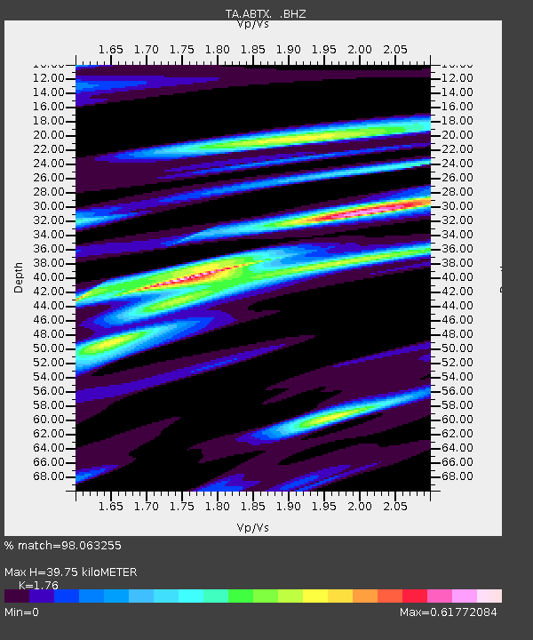
| Estimated Moho Depth: |
39.75 km |
| Estimated Crust Vp/Vs: |
1.76 |
| Assumed Crust Vp: |
6.426 km/s |
| Estimated Crust Vs: |
3.651 km/s |
| Estimated Crust Poisson's Ratio: |
0.26 |
|
| Radial Match: |
98.063255 % |
| Radial Bump: |
312 |
| Transverse Match: |
75.13809 % |
| Transverse Bump: |
400 |
| SOD ConfigId: |
299721 |
| Insert Time: |
2010-04-26 22:16:10.386 +0000 |
| GWidth: |
2.5 |
| Max Bumps: |
400 |
| Tol: |
0.001 |
|

Signal To Noise
| Channel | StoN | STA | LTA |
| TA:ABTX: :BHZ:20100311T14:50:33.299976Z | 26.498077 | 2.7469562E-6 | 1.03666245E-7 |
| TA:ABTX: :BHN:20100311T14:50:33.299976Z | 4.4510317 | 1.1477812E-6 | 2.5786855E-7 |
| TA:ABTX: :BHE:20100311T14:50:33.299976Z | 3.036932 | 6.8339847E-7 | 2.2502923E-7 |
| Arrivals |
| Ps | 4.9 SECOND |
| PpPs | 16 SECOND |
| PsPs/PpSs | 21 SECOND |


