You are here: Home > Network List > NN - Western Great Basin/Eastern Sierra Nevada Stations List
> Station VCN Virginia City, Nevada gps > Earthquake Result Viewer
VCN Virginia City, Nevada gps - Earthquake Result Viewer
| Earthquake location: |
Santiago Del Estero Prov., Arg. |
| Earthquake latitude/longitude: |
-26.7/-63.0 |
| Earthquake time(UTC): |
2023/01/20 (020) 22:09:39 GMT |
| Earthquake Depth: |
611 km |
| Earthquake Magnitude: |
6.8 mww |
| Earthquake Catalog/Contributor: |
NEIC PDE/us |
|
| Network: |
NN Western Great Basin/Eastern Sierra Nevada |
| Station: |
VCN Virginia City, Nevada gps |
| Lat/Lon: |
39.30 N/119.65 W |
| Elevation: |
1928 m |
|
| Distance: |
84.3 deg |
| Az: |
319.372 deg |
| Baz: |
131.362 deg |
| Ray Param: |
0.043788537 |
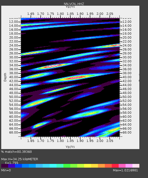
| Estimated Moho Depth: |
34.25 km |
| Estimated Crust Vp/Vs: |
1.75 |
| Assumed Crust Vp: |
6.279 km/s |
| Estimated Crust Vs: |
3.578 km/s |
| Estimated Crust Poisson's Ratio: |
0.26 |
|
| Radial Match: |
80.39368 % |
| Radial Bump: |
400 |
| Transverse Match: |
80.39362 % |
| Transverse Bump: |
400 |
| SOD ConfigId: |
29823551 |
| Insert Time: |
2023-02-03 22:28:47.882 +0000 |
| GWidth: |
2.5 |
| Max Bumps: |
400 |
| Tol: |
0.001 |
|

Signal To Noise
| Channel | StoN | STA | LTA |
| NN:VCN: :HHZ:20230120T22:20:37.263014Z | 7.114629 | 2.2106137E-6 | 3.1071386E-7 |
| $trig.getChannelId() | $trig.getValue() | $trig.getSTA() | $trig.getLTA() |
| NN:VCN: :HHE:20230120T22:20:37.263014Z | 2.7217832 | 7.368894E-7 | 2.707377E-7 |
| Arrivals |
| Ps | 4.2 SECOND |
| PpPs | 15 SECOND |
| PsPs/PpSs | 19 SECOND |


