You are here: Home > Network List > TA - USArray Transportable Network (new EarthScope stations) Stations List
> Station 532A Rocksprings, TX, USA > Earthquake Result Viewer
532A Rocksprings, TX, USA - Earthquake Result Viewer
| Earthquake location: |
Near Coast Of Central Chile |
| Earthquake latitude/longitude: |
-34.3/-71.9 |
| Earthquake time(UTC): |
2010/03/11 (070) 14:39:43 GMT |
| Earthquake Depth: |
11 km |
| Earthquake Magnitude: |
6.7 MB, 7.0 MS, 6.9 MW, 6.9 MW |
| Earthquake Catalog/Contributor: |
WHDF/NEIC |
|
| Network: |
TA USArray Transportable Network (new EarthScope stations) |
| Station: |
532A Rocksprings, TX, USA |
| Lat/Lon: |
30.13 N/99.90 W |
| Elevation: |
703 m |
|
| Distance: |
69.3 deg |
| Az: |
334.218 deg |
| Baz: |
155.439 deg |
| Ray Param: |
0.055725608 |
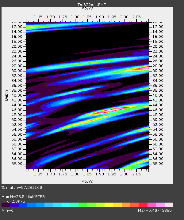
| Estimated Moho Depth: |
28.5 km |
| Estimated Crust Vp/Vs: |
2.10 |
| Assumed Crust Vp: |
6.498 km/s |
| Estimated Crust Vs: |
3.098 km/s |
| Estimated Crust Poisson's Ratio: |
0.35 |
|
| Radial Match: |
97.281166 % |
| Radial Bump: |
400 |
| Transverse Match: |
94.300224 % |
| Transverse Bump: |
400 |
| SOD ConfigId: |
299721 |
| Insert Time: |
2010-04-26 22:16:46.480 +0000 |
| GWidth: |
2.5 |
| Max Bumps: |
400 |
| Tol: |
0.001 |
|
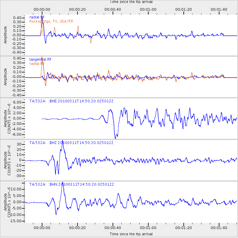
Signal To Noise
| Channel | StoN | STA | LTA |
| TA:532A: :BHZ:20100311T14:50:20.025012Z | 24.30597 | 3.2599703E-6 | 1.341222E-7 |
| TA:532A: :BHN:20100311T14:50:20.025012Z | 5.029183 | 1.1457406E-6 | 2.2781845E-7 |
| TA:532A: :BHE:20100311T14:50:20.025012Z | 4.7951264 | 6.3304446E-7 | 1.320183E-7 |
| Arrivals |
| Ps | 5.0 SECOND |
| PpPs | 13 SECOND |
| PsPs/PpSs | 18 SECOND |


