You are here: Home > Network List > TA - USArray Transportable Network (new EarthScope stations) Stations List
> Station 330A Mertzon, TX, USA > Earthquake Result Viewer
330A Mertzon, TX, USA - Earthquake Result Viewer
| Earthquake location: |
Near Coast Of Central Chile |
| Earthquake latitude/longitude: |
-34.3/-71.9 |
| Earthquake time(UTC): |
2010/03/11 (070) 14:39:43 GMT |
| Earthquake Depth: |
11 km |
| Earthquake Magnitude: |
6.7 MB, 7.0 MS, 6.9 MW, 6.9 MW |
| Earthquake Catalog/Contributor: |
WHDF/NEIC |
|
| Network: |
TA USArray Transportable Network (new EarthScope stations) |
| Station: |
330A Mertzon, TX, USA |
| Lat/Lon: |
31.41 N/101.18 W |
| Elevation: |
742 m |
|
| Distance: |
70.9 deg |
| Az: |
333.736 deg |
| Baz: |
154.628 deg |
| Ray Param: |
0.054652166 |
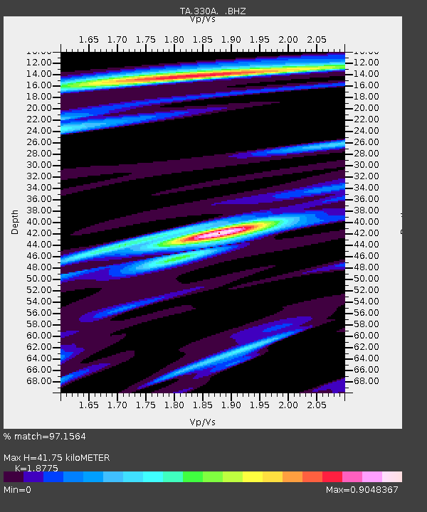
| Estimated Moho Depth: |
41.75 km |
| Estimated Crust Vp/Vs: |
1.88 |
| Assumed Crust Vp: |
6.38 km/s |
| Estimated Crust Vs: |
3.398 km/s |
| Estimated Crust Poisson's Ratio: |
0.30 |
|
| Radial Match: |
97.1564 % |
| Radial Bump: |
340 |
| Transverse Match: |
92.07596 % |
| Transverse Bump: |
400 |
| SOD ConfigId: |
299721 |
| Insert Time: |
2010-04-26 22:17:30.417 +0000 |
| GWidth: |
2.5 |
| Max Bumps: |
400 |
| Tol: |
0.001 |
|

Signal To Noise
| Channel | StoN | STA | LTA |
| TA:330A: :BHZ:20100311T14:50:29.900012Z | 15.776629 | 2.9126643E-6 | 1.8461891E-7 |
| TA:330A: :BHN:20100311T14:50:29.900012Z | 5.656349 | 1.0694546E-6 | 1.8907151E-7 |
| TA:330A: :BHE:20100311T14:50:29.900012Z | 3.2796085 | 5.5587157E-7 | 1.6949326E-7 |
| Arrivals |
| Ps | 5.9 SECOND |
| PpPs | 18 SECOND |
| PsPs/PpSs | 24 SECOND |


