You are here: Home > Network List > TA - USArray Transportable Network (new EarthScope stations) Stations List
> Station 131A Roby, TX, USA > Earthquake Result Viewer
131A Roby, TX, USA - Earthquake Result Viewer
| Earthquake location: |
Near Coast Of Central Chile |
| Earthquake latitude/longitude: |
-34.3/-71.9 |
| Earthquake time(UTC): |
2010/03/11 (070) 14:39:43 GMT |
| Earthquake Depth: |
11 km |
| Earthquake Magnitude: |
6.7 MB, 7.0 MS, 6.9 MW, 6.9 MW |
| Earthquake Catalog/Contributor: |
WHDF/NEIC |
|
| Network: |
TA USArray Transportable Network (new EarthScope stations) |
| Station: |
131A Roby, TX, USA |
| Lat/Lon: |
32.67 N/100.39 W |
| Elevation: |
622 m |
|
| Distance: |
71.8 deg |
| Az: |
334.938 deg |
| Baz: |
155.427 deg |
| Ray Param: |
0.054086022 |
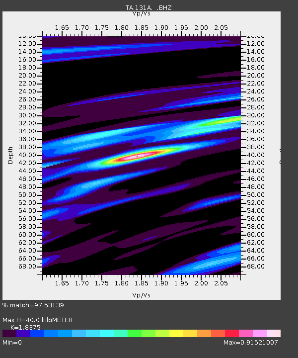
| Estimated Moho Depth: |
40.0 km |
| Estimated Crust Vp/Vs: |
1.84 |
| Assumed Crust Vp: |
6.426 km/s |
| Estimated Crust Vs: |
3.497 km/s |
| Estimated Crust Poisson's Ratio: |
0.29 |
|
| Radial Match: |
97.53139 % |
| Radial Bump: |
316 |
| Transverse Match: |
85.95416 % |
| Transverse Bump: |
400 |
| SOD ConfigId: |
299721 |
| Insert Time: |
2010-04-26 22:18:36.826 +0000 |
| GWidth: |
2.5 |
| Max Bumps: |
400 |
| Tol: |
0.001 |
|

Signal To Noise
| Channel | StoN | STA | LTA |
| TA:131A: :BHZ:20100311T14:50:35.124988Z | 9.991747 | 2.8978063E-6 | 2.9001998E-7 |
| TA:131A: :BHN:20100311T14:50:35.124988Z | 7.4072742 | 1.0828861E-6 | 1.4619226E-7 |
| TA:131A: :BHE:20100311T14:50:35.124988Z | 3.1855958 | 4.933406E-7 | 1.5486604E-7 |
| Arrivals |
| Ps | 5.4 SECOND |
| PpPs | 17 SECOND |
| PsPs/PpSs | 22 SECOND |


