You are here: Home > Network List > US - United States National Seismic Network Stations List
> Station EGMT Eagleton, Montana, USA > Earthquake Result Viewer
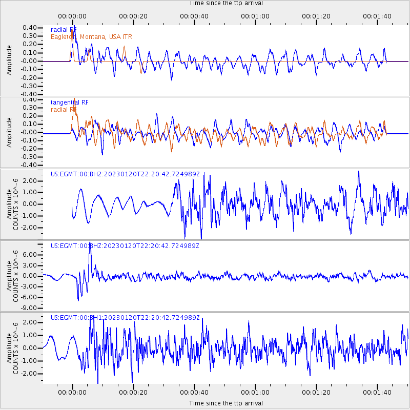
EGMT Eagleton, Montana, USA - Earthquake Result Viewer
*The percent match for this event was below the threshold and hence no stack was calculated.
| Earthquake location: |
Santiago Del Estero Prov., Arg. |
| Earthquake latitude/longitude: |
-26.7/-63.0 |
| Earthquake time(UTC): |
2023/01/20 (020) 22:09:39 GMT |
| Earthquake Depth: |
611 km |
| Earthquake Magnitude: |
6.8 mww |
| Earthquake Catalog/Contributor: |
NEIC PDE/us |
|
| Network: |
US United States National Seismic Network |
| Station: |
EGMT Eagleton, Montana, USA |
| Lat/Lon: |
48.02 N/109.75 W |
| Elevation: |
1055 m |
|
| Distance: |
85.4 deg |
| Az: |
330.643 deg |
| Baz: |
139.217 deg |
| Ray Param: |
$rayparam |
*The percent match for this event was below the threshold and hence was not used in the summary stack. |
|
| Radial Match: |
59.220287 % |
| Radial Bump: |
400 |
| Transverse Match: |
71.68902 % |
| Transverse Bump: |
400 |
| SOD ConfigId: |
29823551 |
| Insert Time: |
2023-02-03 22:39:08.704 +0000 |
| GWidth: |
2.5 |
| Max Bumps: |
400 |
| Tol: |
0.001 |
|
Signal To Noise
| Channel | StoN | STA | LTA |
| US:EGMT:00:BHZ:20230120T22:20:42.724989Z | 4.501682 | 2.577969E-6 | 5.72668E-7 |
| US:EGMT:00:BH1:20230120T22:20:42.724989Z | 1.7107292 | 8.8764097E-7 | 5.18867E-7 |
| US:EGMT:00:BH2:20230120T22:20:42.724989Z | 1.273932 | 8.4756084E-7 | 6.6531095E-7 |
| Arrivals |
| Ps | |
| PpPs | |
| PsPs/PpSs | |


