You are here: Home > Network List > TA - USArray Transportable Network (new EarthScope stations) Stations List
> Station Q29A Oakley, KS, USA > Earthquake Result Viewer
Q29A Oakley, KS, USA - Earthquake Result Viewer

| Earthquake location: |
Near Coast Of Central Chile |
| Earthquake latitude/longitude: |
-34.3/-71.9 |
| Earthquake time(UTC): |
2010/03/11 (070) 14:39:43 GMT |
| Earthquake Depth: |
11 km |
| Earthquake Magnitude: |
6.7 MB, 7.0 MS, 6.9 MW, 6.9 MW |
| Earthquake Catalog/Contributor: |
WHDF/NEIC |
|
| Network: |
TA USArray Transportable Network (new EarthScope stations) |
| Station: |
Q29A Oakley, KS, USA |
| Lat/Lon: |
38.89 N/100.98 W |
| Elevation: |
895 m |
|
| Distance: |
77.6 deg |
| Az: |
337.146 deg |
| Baz: |
155.666 deg |
| Ray Param: |
0.050180577 |
| Estimated Moho Depth: |
53.75 km |
| Estimated Crust Vp/Vs: |
1.68 |
| Assumed Crust Vp: |
6.483 km/s |
| Estimated Crust Vs: |
3.87 km/s |
| Estimated Crust Poisson's Ratio: |
0.22 |
|
| Radial Match: |
96.060776 % |
| Radial Bump: |
400 |
| Transverse Match: |
88.94739 % |
| Transverse Bump: |
400 |
| SOD ConfigId: |
299721 |
| Insert Time: |
2010-04-26 22:21:24.669 +0000 |
| GWidth: |
2.5 |
| Max Bumps: |
400 |
| Tol: |
0.001 |
|
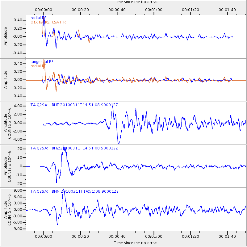
Signal To Noise
| Channel | StoN | STA | LTA |
| TA:Q29A: :BHZ:20100311T14:51:08.900012Z | 7.1057725 | 2.343773E-6 | 3.2984073E-7 |
| TA:Q29A: :BHN:20100311T14:51:08.900012Z | 2.6282508 | 1.0340075E-6 | 3.934204E-7 |
| TA:Q29A: :BHE:20100311T14:51:08.900012Z | 2.8173985 | 5.1379004E-7 | 1.8236328E-7 |
| Arrivals |
| Ps | 5.8 SECOND |
| PpPs | 21 SECOND |
| PsPs/PpSs | 27 SECOND |


