You are here: Home > Network List > UW - Pacific Northwest Regional Seismic Network Stations List
> Station UMAT Pilot Rock, OR, USA > Earthquake Result Viewer
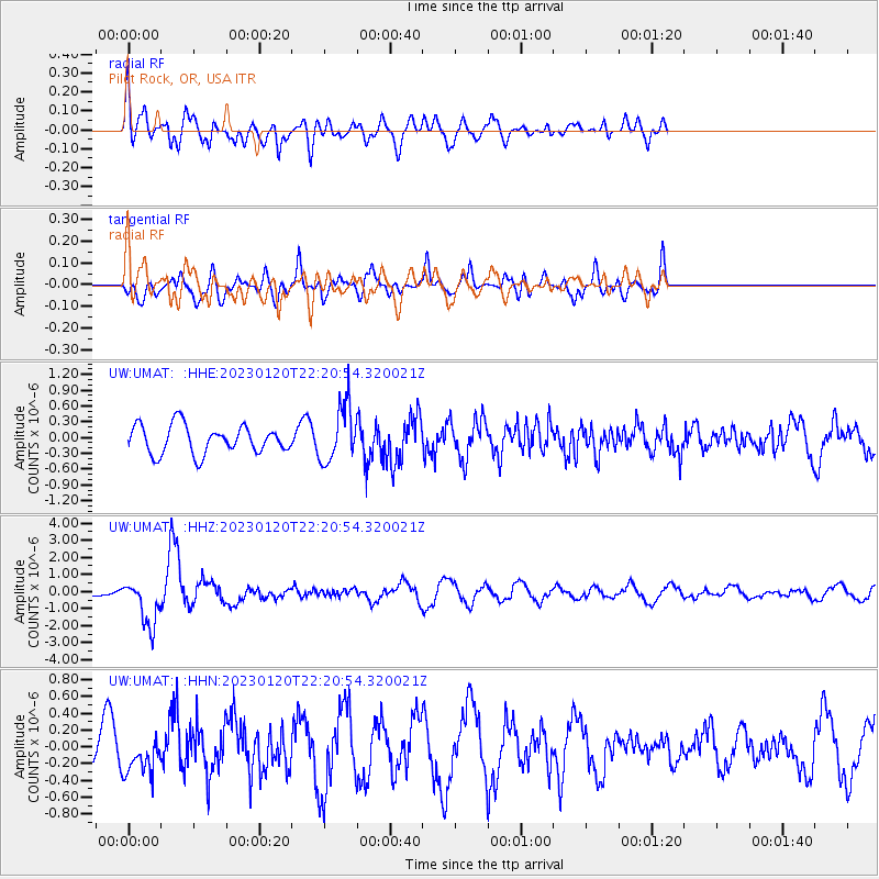
UMAT Pilot Rock, OR, USA - Earthquake Result Viewer
*The percent match for this event was below the threshold and hence no stack was calculated.
| Earthquake location: |
Santiago Del Estero Prov., Arg. |
| Earthquake latitude/longitude: |
-26.7/-63.0 |
| Earthquake time(UTC): |
2023/01/20 (020) 22:09:39 GMT |
| Earthquake Depth: |
611 km |
| Earthquake Magnitude: |
6.8 mww |
| Earthquake Catalog/Contributor: |
NEIC PDE/us |
|
| Network: |
UW Pacific Northwest Regional Seismic Network |
| Station: |
UMAT Pilot Rock, OR, USA |
| Lat/Lon: |
45.29 N/118.96 W |
| Elevation: |
1318 m |
|
| Distance: |
87.9 deg |
| Az: |
324.192 deg |
| Baz: |
132.157 deg |
| Ray Param: |
$rayparam |
*The percent match for this event was below the threshold and hence was not used in the summary stack. |
|
| Radial Match: |
68.706055 % |
| Radial Bump: |
400 |
| Transverse Match: |
54.05261 % |
| Transverse Bump: |
400 |
| SOD ConfigId: |
29823551 |
| Insert Time: |
2023-02-03 22:43:31.048 +0000 |
| GWidth: |
2.5 |
| Max Bumps: |
400 |
| Tol: |
0.001 |
|
Signal To Noise
| Channel | StoN | STA | LTA |
| UW:UMAT: :HHZ:20230120T22:20:54.320021Z | 3.7556753 | 1.3440218E-6 | 3.5786422E-7 |
| UW:UMAT: :HHN:20230120T22:20:54.320021Z | 1.041978 | 2.2317094E-7 | 2.1418009E-7 |
| UW:UMAT: :HHE:20230120T22:20:54.320021Z | 2.0212831 | 5.3653326E-7 | 2.654419E-7 |
| Arrivals |
| Ps | |
| PpPs | |
| PsPs/PpSs | |


