You are here: Home > Network List > TA - USArray Transportable Network (new EarthScope stations) Stations List
> Station I27A Quinn, SD, USA > Earthquake Result Viewer
I27A Quinn, SD, USA - Earthquake Result Viewer
| Earthquake location: |
Near Coast Of Central Chile |
| Earthquake latitude/longitude: |
-34.3/-71.9 |
| Earthquake time(UTC): |
2010/03/11 (070) 14:39:43 GMT |
| Earthquake Depth: |
11 km |
| Earthquake Magnitude: |
6.7 MB, 7.0 MS, 6.9 MW, 6.9 MW |
| Earthquake Catalog/Contributor: |
WHDF/NEIC |
|
| Network: |
TA USArray Transportable Network (new EarthScope stations) |
| Station: |
I27A Quinn, SD, USA |
| Lat/Lon: |
44.07 N/102.05 W |
| Elevation: |
867 m |
|
| Distance: |
82.7 deg |
| Az: |
338.583 deg |
| Baz: |
155.203 deg |
| Ray Param: |
0.04671378 |
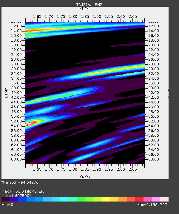
| Estimated Moho Depth: |
53.0 km |
| Estimated Crust Vp/Vs: |
1.61 |
| Assumed Crust Vp: |
6.242 km/s |
| Estimated Crust Vs: |
3.883 km/s |
| Estimated Crust Poisson's Ratio: |
0.18 |
|
| Radial Match: |
94.04376 % |
| Radial Bump: |
400 |
| Transverse Match: |
86.46111 % |
| Transverse Bump: |
400 |
| SOD ConfigId: |
299721 |
| Insert Time: |
2010-04-26 22:23:43.965 +0000 |
| GWidth: |
2.5 |
| Max Bumps: |
400 |
| Tol: |
0.001 |
|

Signal To Noise
| Channel | StoN | STA | LTA |
| TA:I27A: :BHZ:20100311T14:51:35.999988Z | 5.714632 | 2.6167481E-6 | 4.5790316E-7 |
| TA:I27A: :BHN:20100311T14:51:35.999988Z | 1.5891942 | 1.2139701E-6 | 7.6389034E-7 |
| TA:I27A: :BHE:20100311T14:51:35.999988Z | 1.1180577 | 7.6763934E-7 | 6.865829E-7 |
| Arrivals |
| Ps | 5.3 SECOND |
| PpPs | 22 SECOND |
| PsPs/PpSs | 27 SECOND |


