You are here: Home > Network List > TA - USArray Transportable Network (new EarthScope stations) Stations List
> Station I26A New Underwood, SD, USA > Earthquake Result Viewer
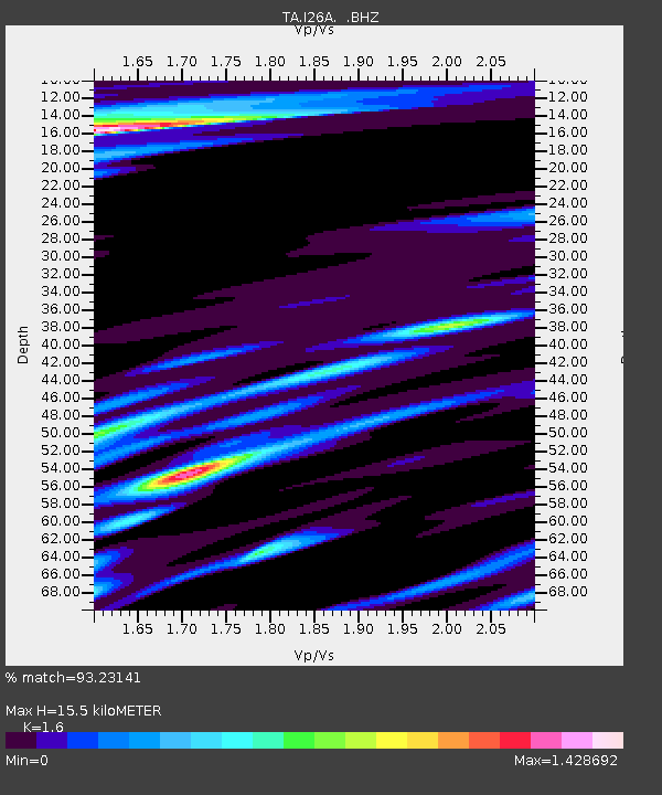
I26A New Underwood, SD, USA - Earthquake Result Viewer
| Earthquake location: |
Near Coast Of Central Chile |
| Earthquake latitude/longitude: |
-34.3/-71.9 |
| Earthquake time(UTC): |
2010/03/11 (070) 14:39:43 GMT |
| Earthquake Depth: |
11 km |
| Earthquake Magnitude: |
6.7 MB, 7.0 MS, 6.9 MW, 6.9 MW |
| Earthquake Catalog/Contributor: |
WHDF/NEIC |
|
| Network: |
TA USArray Transportable Network (new EarthScope stations) |
| Station: |
I26A New Underwood, SD, USA |
| Lat/Lon: |
44.03 N/102.86 W |
| Elevation: |
971 m |
|
| Distance: |
82.9 deg |
| Az: |
338.036 deg |
| Baz: |
154.575 deg |
| Ray Param: |
0.04656607 |
| Estimated Moho Depth: |
15.5 km |
| Estimated Crust Vp/Vs: |
1.60 |
| Assumed Crust Vp: |
6.242 km/s |
| Estimated Crust Vs: |
3.901 km/s |
| Estimated Crust Poisson's Ratio: |
0.18 |
|
| Radial Match: |
93.23141 % |
| Radial Bump: |
400 |
| Transverse Match: |
87.45678 % |
| Transverse Bump: |
400 |
| SOD ConfigId: |
299721 |
| Insert Time: |
2010-04-26 22:23:45.669 +0000 |
| GWidth: |
2.5 |
| Max Bumps: |
400 |
| Tol: |
0.001 |
|

Signal To Noise
| Channel | StoN | STA | LTA |
| TA:I26A: :BHZ:20100311T14:51:37.100024Z | 8.407816 | 2.847859E-6 | 3.3871567E-7 |
| TA:I26A: :BHN:20100311T14:51:37.100024Z | 0.84505343 | 7.819032E-7 | 9.2527074E-7 |
| TA:I26A: :BHE:20100311T14:51:37.100024Z | 1.4259357 | 9.696955E-7 | 6.800415E-7 |
| Arrivals |
| Ps | 1.5 SECOND |
| PpPs | 6.3 SECOND |
| PsPs/PpSs | 7.8 SECOND |


