You are here: Home > Network List > GM - US Geological Survey Networks Stations List
> Station IWM01 Jericho 2M Well Monitoring Station > Earthquake Result Viewer
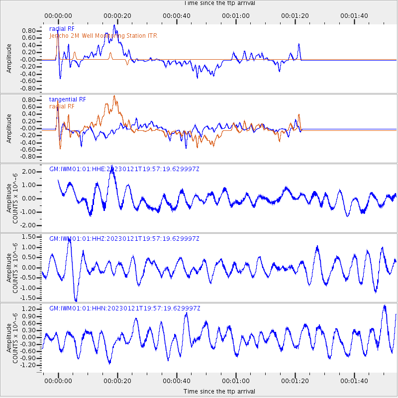
IWM01 Jericho 2M Well Monitoring Station - Earthquake Result Viewer
*The percent match for this event was below the threshold and hence no stack was calculated.
| Earthquake location: |
Reykjanes Ridge |
| Earthquake latitude/longitude: |
57.4/-33.4 |
| Earthquake time(UTC): |
2023/01/21 (021) 19:49:28 GMT |
| Earthquake Depth: |
10 km |
| Earthquake Magnitude: |
5.7 mww |
| Earthquake Catalog/Contributor: |
NEIC PDE/us |
|
| Network: |
GM US Geological Survey Networks |
| Station: |
IWM01 Jericho 2M Well Monitoring Station |
| Lat/Lon: |
36.73 N/96.53 W |
| Elevation: |
328 m |
|
| Distance: |
45.8 deg |
| Az: |
271.38 deg |
| Baz: |
42.344 deg |
| Ray Param: |
$rayparam |
*The percent match for this event was below the threshold and hence was not used in the summary stack. |
|
| Radial Match: |
48.863064 % |
| Radial Bump: |
400 |
| Transverse Match: |
51.878326 % |
| Transverse Bump: |
400 |
| SOD ConfigId: |
29823551 |
| Insert Time: |
2023-02-04 20:02:03.087 +0000 |
| GWidth: |
2.5 |
| Max Bumps: |
400 |
| Tol: |
0.001 |
|
Signal To Noise
| Channel | StoN | STA | LTA |
| GM:IWM01:01:HHZ:20230121T19:57:19.629997Z | 2.2261171 | 7.174439E-7 | 3.2228488E-7 |
| GM:IWM01:01:HHN:20230121T19:57:19.629997Z | 0.8334107 | 5.5967297E-7 | 6.7154525E-7 |
| GM:IWM01:01:HHE:20230121T19:57:19.629997Z | 1.3294272 | 1.0242401E-6 | 7.704371E-7 |
| Arrivals |
| Ps | |
| PpPs | |
| PsPs/PpSs | |


