You are here: Home > Network List > TA - USArray Transportable Network (new EarthScope stations) Stations List
> Station F27A Lemmon, SD, USA > Earthquake Result Viewer
F27A Lemmon, SD, USA - Earthquake Result Viewer

| Earthquake location: |
Near Coast Of Central Chile |
| Earthquake latitude/longitude: |
-34.3/-71.9 |
| Earthquake time(UTC): |
2010/03/11 (070) 14:39:43 GMT |
| Earthquake Depth: |
11 km |
| Earthquake Magnitude: |
6.7 MB, 7.0 MS, 6.9 MW, 6.9 MW |
| Earthquake Catalog/Contributor: |
WHDF/NEIC |
|
| Network: |
TA USArray Transportable Network (new EarthScope stations) |
| Station: |
F27A Lemmon, SD, USA |
| Lat/Lon: |
45.87 N/102.02 W |
| Elevation: |
757 m |
|
| Distance: |
84.3 deg |
| Az: |
339.364 deg |
| Baz: |
155.314 deg |
| Ray Param: |
0.045570403 |
| Estimated Moho Depth: |
15.0 km |
| Estimated Crust Vp/Vs: |
1.69 |
| Assumed Crust Vp: |
6.242 km/s |
| Estimated Crust Vs: |
3.699 km/s |
| Estimated Crust Poisson's Ratio: |
0.23 |
|
| Radial Match: |
89.62749 % |
| Radial Bump: |
317 |
| Transverse Match: |
87.88394 % |
| Transverse Bump: |
394 |
| SOD ConfigId: |
299721 |
| Insert Time: |
2010-04-26 22:24:39.088 +0000 |
| GWidth: |
2.5 |
| Max Bumps: |
400 |
| Tol: |
0.001 |
|
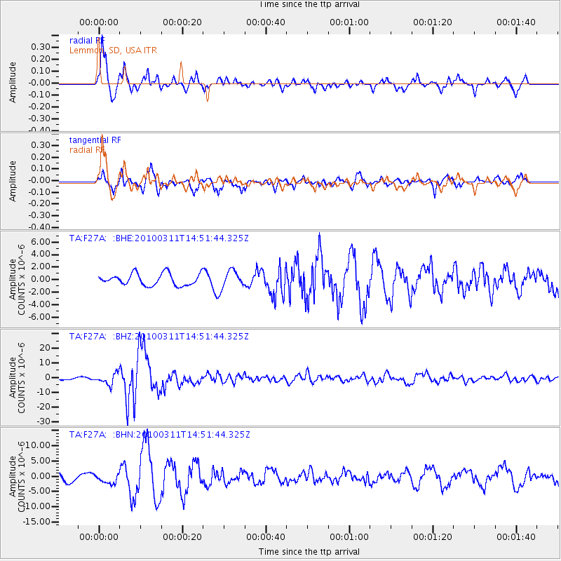
Signal To Noise
| Channel | StoN | STA | LTA |
| TA:F27A: :BHZ:20100311T14:51:44.325Z | 5.39848 | 3.816968E-6 | 7.0704493E-7 |
| TA:F27A: :BHN:20100311T14:51:44.325Z | 1.3703218 | 1.5251626E-6 | 1.112996E-6 |
| TA:F27A: :BHE:20100311T14:51:44.325Z | 1.4296503 | 1.3322441E-6 | 9.3186713E-7 |
| Arrivals |
| Ps | 1.7 SECOND |
| PpPs | 6.3 SECOND |
| PsPs/PpSs | 8.0 SECOND |


