You are here: Home > Network List > TA - USArray Transportable Network (new EarthScope stations) Stations List
> Station F28A McLaughlin, SD, USA > Earthquake Result Viewer
F28A McLaughlin, SD, USA - Earthquake Result Viewer

| Earthquake location: |
Near Coast Of Central Chile |
| Earthquake latitude/longitude: |
-34.3/-71.9 |
| Earthquake time(UTC): |
2010/03/11 (070) 14:39:43 GMT |
| Earthquake Depth: |
11 km |
| Earthquake Magnitude: |
6.7 MB, 7.0 MS, 6.9 MW, 6.9 MW |
| Earthquake Catalog/Contributor: |
WHDF/NEIC |
|
| Network: |
TA USArray Transportable Network (new EarthScope stations) |
| Station: |
F28A McLaughlin, SD, USA |
| Lat/Lon: |
45.85 N/100.80 W |
| Elevation: |
633 m |
|
| Distance: |
83.9 deg |
| Az: |
340.136 deg |
| Baz: |
156.265 deg |
| Ray Param: |
0.045827176 |
| Estimated Moho Depth: |
46.75 km |
| Estimated Crust Vp/Vs: |
1.80 |
| Assumed Crust Vp: |
6.53 km/s |
| Estimated Crust Vs: |
3.623 km/s |
| Estimated Crust Poisson's Ratio: |
0.28 |
|
| Radial Match: |
95.57842 % |
| Radial Bump: |
400 |
| Transverse Match: |
86.52528 % |
| Transverse Bump: |
400 |
| SOD ConfigId: |
299721 |
| Insert Time: |
2010-04-26 22:27:34.675 +0000 |
| GWidth: |
2.5 |
| Max Bumps: |
400 |
| Tol: |
0.001 |
|
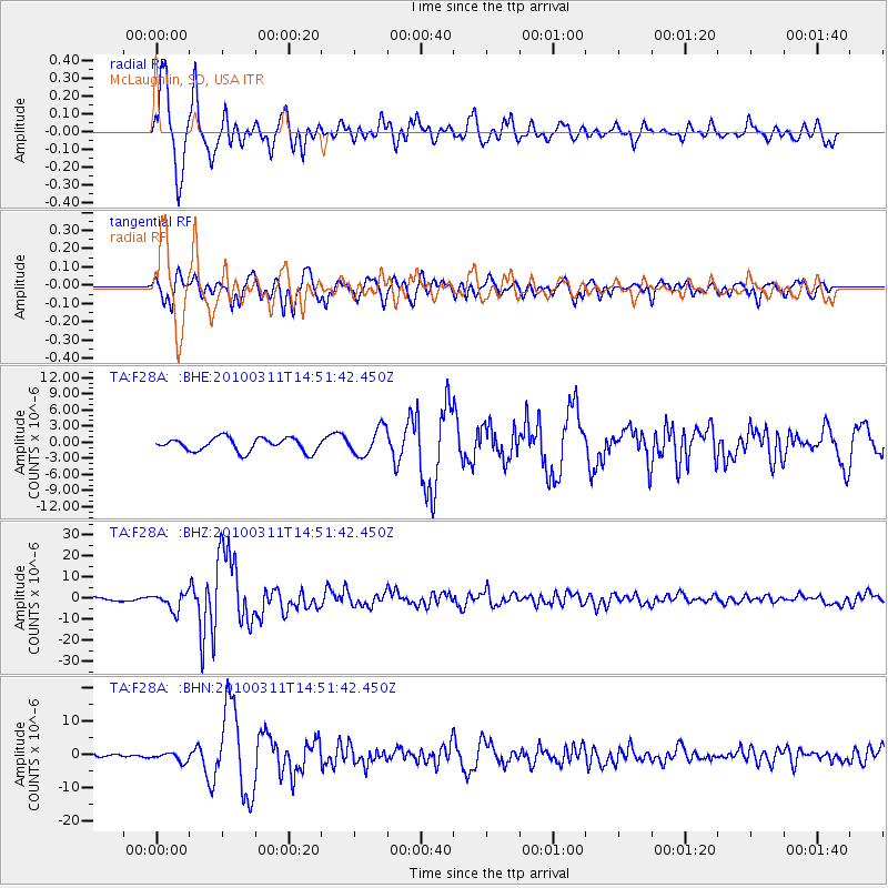
Signal To Noise
| Channel | StoN | STA | LTA |
| TA:F28A: :BHZ:20100311T14:51:42.450Z | 5.285517 | 4.025512E-6 | 7.616118E-7 |
| TA:F28A: :BHN:20100311T14:51:42.450Z | 2.2286386 | 1.3082065E-6 | 5.86998E-7 |
| TA:F28A: :BHE:20100311T14:51:42.450Z | 2.0366423 | 2.5349468E-6 | 1.2446695E-6 |
| Arrivals |
| Ps | 5.9 SECOND |
| PpPs | 20 SECOND |
| PsPs/PpSs | 25 SECOND |


