You are here: Home > Network List > AV - Alaska Volcano Observatory Stations List
> Station MAPS Pakushin Southeast, Makushin Volcano, Alaska > Earthquake Result Viewer
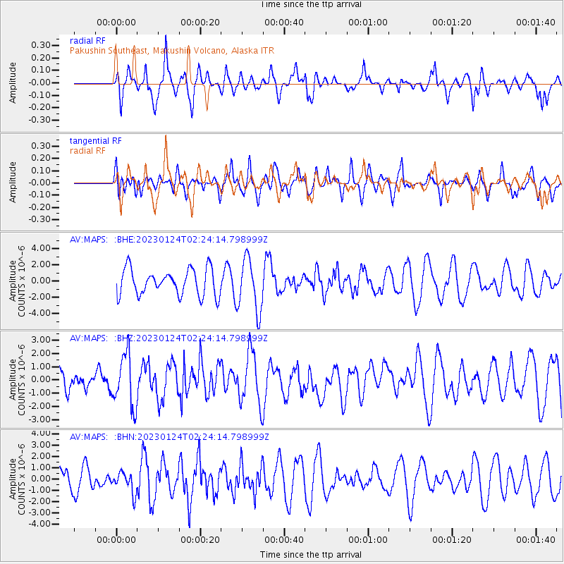
MAPS Pakushin Southeast, Makushin Volcano, Alaska - Earthquake Result Viewer
*The percent match for this event was below the threshold and hence no stack was calculated.
| Earthquake location: |
Northern Molucca Sea |
| Earthquake latitude/longitude: |
2.8/126.9 |
| Earthquake time(UTC): |
2023/01/24 (024) 02:13:14 GMT |
| Earthquake Depth: |
35 km |
| Earthquake Magnitude: |
5.8 Mww |
| Earthquake Catalog/Contributor: |
NEIC PDE/us |
|
| Network: |
AV Alaska Volcano Observatory |
| Station: |
MAPS Pakushin Southeast, Makushin Volcano, Alaska |
| Lat/Lon: |
53.81 N/166.94 W |
| Elevation: |
333 m |
|
| Distance: |
73.8 deg |
| Az: |
34.384 deg |
| Baz: |
252.005 deg |
| Ray Param: |
$rayparam |
*The percent match for this event was below the threshold and hence was not used in the summary stack. |
|
| Radial Match: |
46.103504 % |
| Radial Bump: |
400 |
| Transverse Match: |
49.17545 % |
| Transverse Bump: |
400 |
| SOD ConfigId: |
29823551 |
| Insert Time: |
2023-02-07 02:17:58.180 +0000 |
| GWidth: |
2.5 |
| Max Bumps: |
400 |
| Tol: |
0.001 |
|
Signal To Noise
| Channel | StoN | STA | LTA |
| AV:MAPS: :BHZ:20230124T02:24:14.798999Z | 2.030942 | 2.0225264E-6 | 9.958562E-7 |
| AV:MAPS: :BHN:20230124T02:24:14.798999Z | 0.5680504 | 9.584327E-7 | 1.6872318E-6 |
| AV:MAPS: :BHE:20230124T02:24:14.798999Z | 2.0036907 | 3.2362273E-6 | 1.6151331E-6 |
| Arrivals |
| Ps | |
| PpPs | |
| PsPs/PpSs | |


