You are here: Home > Network List > TA - USArray Transportable Network (new EarthScope stations) Stations List
> Station I29A Vivian, Onida, SD, USA > Earthquake Result Viewer
I29A Vivian, Onida, SD, USA - Earthquake Result Viewer
| Earthquake location: |
Near Coast Of Central Chile |
| Earthquake latitude/longitude: |
-34.3/-71.9 |
| Earthquake time(UTC): |
2010/03/11 (070) 14:39:43 GMT |
| Earthquake Depth: |
11 km |
| Earthquake Magnitude: |
6.7 MB, 7.0 MS, 6.9 MW, 6.9 MW |
| Earthquake Catalog/Contributor: |
WHDF/NEIC |
|
| Network: |
TA USArray Transportable Network (new EarthScope stations) |
| Station: |
I29A Vivian, Onida, SD, USA |
| Lat/Lon: |
44.02 N/100.30 W |
| Elevation: |
592 m |
|
| Distance: |
82.1 deg |
| Az: |
339.725 deg |
| Baz: |
156.565 deg |
| Ray Param: |
0.047101326 |
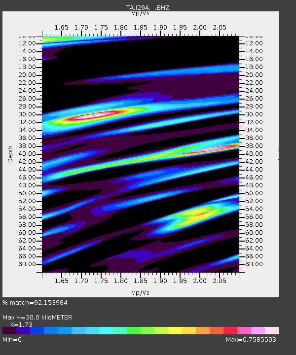
| Estimated Moho Depth: |
30.0 km |
| Estimated Crust Vp/Vs: |
1.73 |
| Assumed Crust Vp: |
6.53 km/s |
| Estimated Crust Vs: |
3.775 km/s |
| Estimated Crust Poisson's Ratio: |
0.25 |
|
| Radial Match: |
92.153984 % |
| Radial Bump: |
400 |
| Transverse Match: |
81.08123 % |
| Transverse Bump: |
400 |
| SOD ConfigId: |
299721 |
| Insert Time: |
2010-04-26 22:28:52.571 +0000 |
| GWidth: |
2.5 |
| Max Bumps: |
400 |
| Tol: |
0.001 |
|
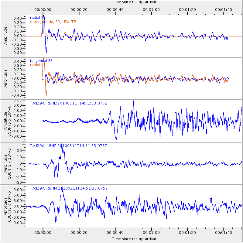
Signal To Noise
| Channel | StoN | STA | LTA |
| TA:I29A: :BHZ:20100311T14:51:33.075Z | 9.916004 | 2.7475533E-6 | 2.770827E-7 |
| TA:I29A: :BHN:20100311T14:51:33.075Z | 3.9088223 | 1.447E-6 | 3.7018825E-7 |
| TA:I29A: :BHE:20100311T14:51:33.075Z | 1.4613717 | 5.26011E-7 | 3.5994336E-7 |
| Arrivals |
| Ps | 3.4 SECOND |
| PpPs | 12 SECOND |
| PsPs/PpSs | 16 SECOND |


