You are here: Home > Network List > TA - USArray Transportable Network (new EarthScope stations) Stations List
> Station O31A Woollen Ranch, Alma, NE, USA > Earthquake Result Viewer
O31A Woollen Ranch, Alma, NE, USA - Earthquake Result Viewer
| Earthquake location: |
Near Coast Of Central Chile |
| Earthquake latitude/longitude: |
-34.3/-71.9 |
| Earthquake time(UTC): |
2010/03/11 (070) 14:39:43 GMT |
| Earthquake Depth: |
11 km |
| Earthquake Magnitude: |
6.7 MB, 7.0 MS, 6.9 MW, 6.9 MW |
| Earthquake Catalog/Contributor: |
WHDF/NEIC |
|
| Network: |
TA USArray Transportable Network (new EarthScope stations) |
| Station: |
O31A Woollen Ranch, Alma, NE, USA |
| Lat/Lon: |
40.15 N/99.33 W |
| Elevation: |
631 m |
|
| Distance: |
78.3 deg |
| Az: |
338.86 deg |
| Baz: |
157.071 deg |
| Ray Param: |
0.049743377 |
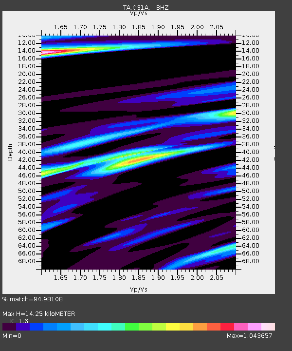
| Estimated Moho Depth: |
14.25 km |
| Estimated Crust Vp/Vs: |
1.60 |
| Assumed Crust Vp: |
6.53 km/s |
| Estimated Crust Vs: |
4.082 km/s |
| Estimated Crust Poisson's Ratio: |
0.18 |
|
| Radial Match: |
94.98108 % |
| Radial Bump: |
400 |
| Transverse Match: |
85.72779 % |
| Transverse Bump: |
400 |
| SOD ConfigId: |
299721 |
| Insert Time: |
2010-04-26 22:28:54.708 +0000 |
| GWidth: |
2.5 |
| Max Bumps: |
400 |
| Tol: |
0.001 |
|
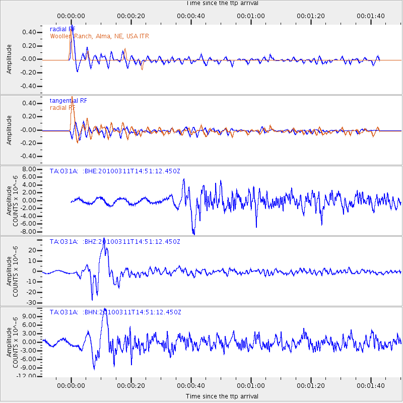
Signal To Noise
| Channel | StoN | STA | LTA |
| TA:O31A: :BHZ:20100311T14:51:12.450Z | 2.6487858 | 2.4209282E-6 | 9.139766E-7 |
| TA:O31A: :BHN:20100311T14:51:12.450Z | 1.6439227 | 1.2623854E-6 | 7.6791036E-7 |
| TA:O31A: :BHE:20100311T14:51:12.450Z | 1.2726151 | 8.127922E-7 | 6.386788E-7 |
| Arrivals |
| Ps | 1.4 SECOND |
| PpPs | 5.5 SECOND |
| PsPs/PpSs | 6.8 SECOND |


