You are here: Home > Network List > TA - USArray Transportable Network (new EarthScope stations) Stations List
> Station X33A Lawton, OK, USA > Earthquake Result Viewer
X33A Lawton, OK, USA - Earthquake Result Viewer
| Earthquake location: |
Near Coast Of Central Chile |
| Earthquake latitude/longitude: |
-34.3/-71.9 |
| Earthquake time(UTC): |
2010/03/11 (070) 14:39:43 GMT |
| Earthquake Depth: |
11 km |
| Earthquake Magnitude: |
6.7 MB, 7.0 MS, 6.9 MW, 6.9 MW |
| Earthquake Catalog/Contributor: |
WHDF/NEIC |
|
| Network: |
TA USArray Transportable Network (new EarthScope stations) |
| Station: |
X33A Lawton, OK, USA |
| Lat/Lon: |
34.54 N/98.50 W |
| Elevation: |
346 m |
|
| Distance: |
72.9 deg |
| Az: |
337.238 deg |
| Baz: |
157.166 deg |
| Ray Param: |
0.053375468 |
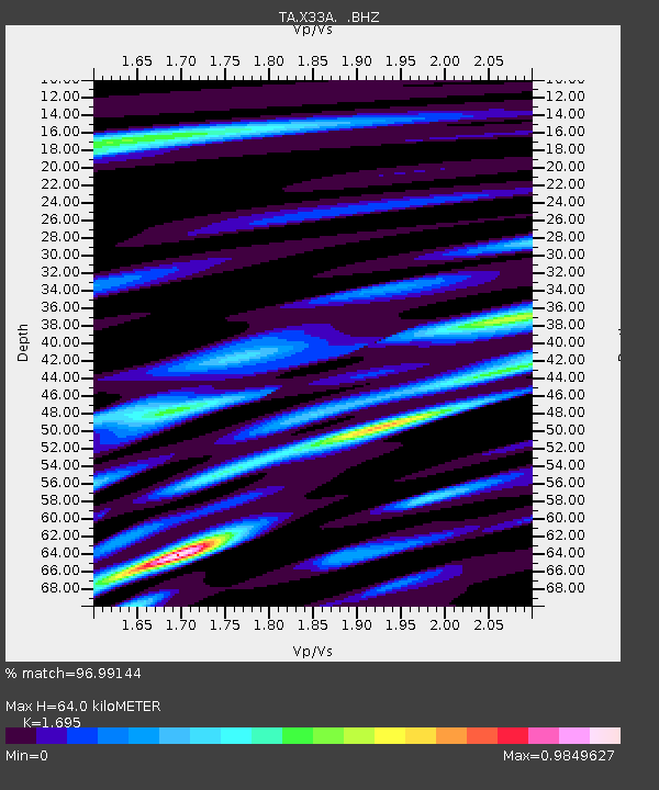
| Estimated Moho Depth: |
64.0 km |
| Estimated Crust Vp/Vs: |
1.70 |
| Assumed Crust Vp: |
6.315 km/s |
| Estimated Crust Vs: |
3.726 km/s |
| Estimated Crust Poisson's Ratio: |
0.23 |
|
| Radial Match: |
96.99144 % |
| Radial Bump: |
400 |
| Transverse Match: |
84.23346 % |
| Transverse Bump: |
400 |
| SOD ConfigId: |
299721 |
| Insert Time: |
2010-04-26 22:31:06.895 +0000 |
| GWidth: |
2.5 |
| Max Bumps: |
400 |
| Tol: |
0.001 |
|
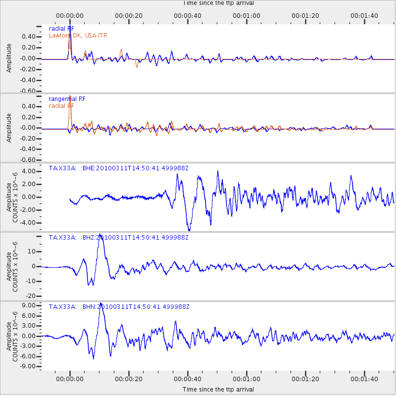
Signal To Noise
| Channel | StoN | STA | LTA |
| TA:X33A: :BHZ:20100311T14:50:41.499988Z | 16.920187 | 2.874282E-6 | 1.6987293E-7 |
| TA:X33A: :BHN:20100311T14:50:41.499988Z | 3.521339 | 1.1651947E-6 | 3.3089535E-7 |
| TA:X33A: :BHE:20100311T14:50:41.499988Z | 2.2762403 | 7.0669745E-7 | 3.1046696E-7 |
| Arrivals |
| Ps | 7.3 SECOND |
| PpPs | 26 SECOND |
| PsPs/PpSs | 34 SECOND |


