You are here: Home > Network List > US - United States National Seismic Network Stations List
> Station MSO Missoula, Montana, USA > Earthquake Result Viewer
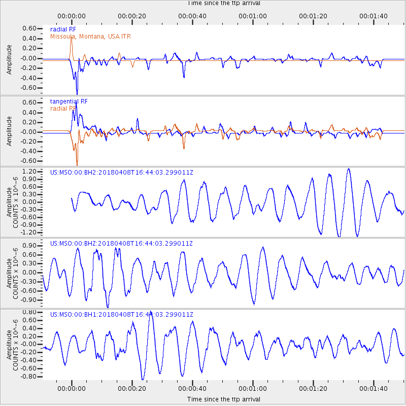
MSO Missoula, Montana, USA - Earthquake Result Viewer
*The percent match for this event was below the threshold and hence no stack was calculated.
| Earthquake location: |
Western Honshu, Japan |
| Earthquake latitude/longitude: |
35.3/132.5 |
| Earthquake time(UTC): |
2018/04/08 (098) 16:32:31 GMT |
| Earthquake Depth: |
9.4 km |
| Earthquake Magnitude: |
5.7 Mww |
| Earthquake Catalog/Contributor: |
NEIC PDE/us |
|
| Network: |
US United States National Seismic Network |
| Station: |
MSO Missoula, Montana, USA |
| Lat/Lon: |
46.83 N/113.94 W |
| Elevation: |
1264 m |
|
| Distance: |
78.8 deg |
| Az: |
39.92 deg |
| Baz: |
310.106 deg |
| Ray Param: |
$rayparam |
*The percent match for this event was below the threshold and hence was not used in the summary stack. |
|
| Radial Match: |
82.410126 % |
| Radial Bump: |
400 |
| Transverse Match: |
87.852684 % |
| Transverse Bump: |
400 |
| SOD ConfigId: |
2973751 |
| Insert Time: |
2018-10-09 10:50:29.671 +0000 |
| GWidth: |
2.5 |
| Max Bumps: |
400 |
| Tol: |
0.001 |
|
Signal To Noise
| Channel | StoN | STA | LTA |
| US:MSO:00:BHZ:20180408T16:44:03.299011Z | 1.6048546 | 5.7713333E-7 | 3.596172E-7 |
| US:MSO:00:BH1:20180408T16:44:03.299011Z | 0.8655632 | 1.5794805E-7 | 1.824801E-7 |
| US:MSO:00:BH2:20180408T16:44:03.299011Z | 2.1831458 | 4.826689E-7 | 2.2108871E-7 |
| Arrivals |
| Ps | |
| PpPs | |
| PsPs/PpSs | |


