You are here: Home > Network List > US - United States National Seismic Network Stations List
> Station MSO Missoula, Montana, USA > Earthquake Result Viewer
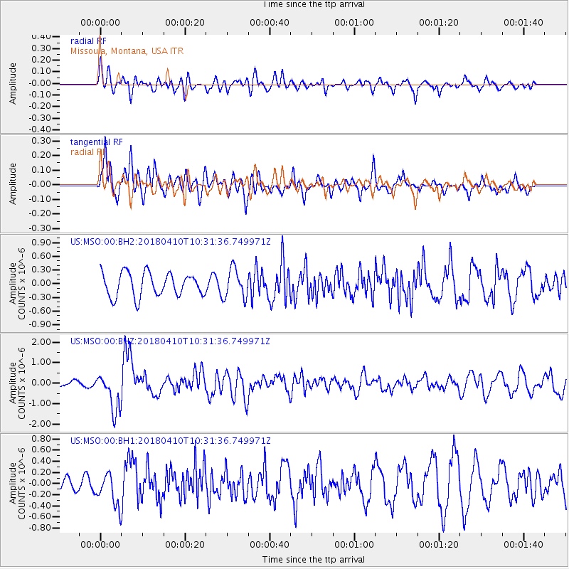
MSO Missoula, Montana, USA - Earthquake Result Viewer
*The percent match for this event was below the threshold and hence no stack was calculated.
| Earthquake location: |
Near Coast Of Central Chile |
| Earthquake latitude/longitude: |
-31.0/-71.6 |
| Earthquake time(UTC): |
2018/04/10 (100) 10:19:34 GMT |
| Earthquake Depth: |
76 km |
| Earthquake Magnitude: |
6.2 Mww |
| Earthquake Catalog/Contributor: |
NEIC PDE/us |
|
| Network: |
US United States National Seismic Network |
| Station: |
MSO Missoula, Montana, USA |
| Lat/Lon: |
46.83 N/113.94 W |
| Elevation: |
1264 m |
|
| Distance: |
86.4 deg |
| Az: |
332.369 deg |
| Baz: |
144.544 deg |
| Ray Param: |
$rayparam |
*The percent match for this event was below the threshold and hence was not used in the summary stack. |
|
| Radial Match: |
57.34368 % |
| Radial Bump: |
400 |
| Transverse Match: |
64.07109 % |
| Transverse Bump: |
400 |
| SOD ConfigId: |
2973751 |
| Insert Time: |
2018-10-09 10:55:00.402 +0000 |
| GWidth: |
2.5 |
| Max Bumps: |
400 |
| Tol: |
0.001 |
|
Signal To Noise
| Channel | StoN | STA | LTA |
| US:MSO:00:BHZ:20180410T10:31:36.749971Z | 3.8682823 | 9.458631E-7 | 2.445176E-7 |
| US:MSO:00:BH1:20180410T10:31:36.749971Z | 2.6160884 | 2.9883398E-7 | 1.14229316E-7 |
| US:MSO:00:BH2:20180410T10:31:36.749971Z | 1.2599841 | 3.2407218E-7 | 2.572034E-7 |
| Arrivals |
| Ps | |
| PpPs | |
| PsPs/PpSs | |


