You are here: Home > Network List > G - GEOSCOPE Stations List
> Station TAM Tamanrasset, Algeria > Earthquake Result Viewer
TAM Tamanrasset, Algeria - Earthquake Result Viewer
| Earthquake location: |
Santiago Del Estero Prov., Arg. |
| Earthquake latitude/longitude: |
-26.7/-63.1 |
| Earthquake time(UTC): |
2023/01/24 (024) 18:37:00 GMT |
| Earthquake Depth: |
596 km |
| Earthquake Magnitude: |
6.4 mww |
| Earthquake Catalog/Contributor: |
NEIC PDE/us |
|
| Network: |
G GEOSCOPE |
| Station: |
TAM Tamanrasset, Algeria |
| Lat/Lon: |
22.79 N/5.53 E |
| Elevation: |
1377 m |
|
| Distance: |
82.6 deg |
| Az: |
60.07 deg |
| Baz: |
237.123 deg |
| Ray Param: |
0.044961292 |
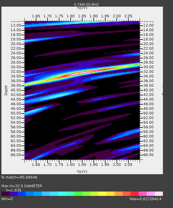
| Estimated Moho Depth: |
32.5 km |
| Estimated Crust Vp/Vs: |
1.84 |
| Assumed Crust Vp: |
6.61 km/s |
| Estimated Crust Vs: |
3.602 km/s |
| Estimated Crust Poisson's Ratio: |
0.29 |
|
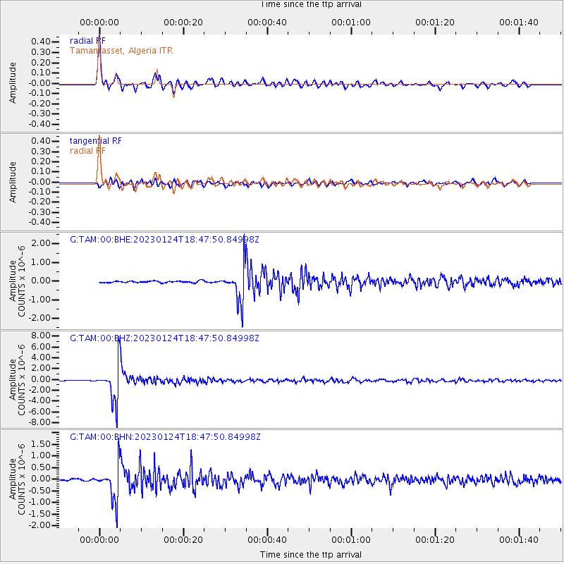
| Radial Match: |
95.86546 % |
| Radial Bump: |
400 |
| Transverse Match: |
86.45171 % |
| Transverse Bump: |
400 |
| SOD ConfigId: |
29823551 |
| Insert Time: |
2023-02-07 18:46:52.374 +0000 |
| GWidth: |
2.5 |
| Max Bumps: |
400 |
| Tol: |
0.001 |
|
Signal To Noise
| Channel | StoN | STA | LTA |
| G:TAM:00:BHZ:20230124T18:47:50.84998Z | 67.058556 | 3.408183E-6 | 5.0823985E-8 |
| G:TAM:00:BHN:20230124T18:47:50.84998Z | 22.175056 | 7.3025825E-7 | 3.2931517E-8 |
| G:TAM:00:BHE:20230124T18:47:50.84998Z | 20.705618 | 9.100098E-7 | 4.39499E-8 |
| Arrivals |
| Ps | 4.2 SECOND |
| PpPs | 14 SECOND |
| PsPs/PpSs | 18 SECOND |


