You are here: Home > Network List > TA - USArray Transportable Network (new EarthScope stations) Stations List
> Station 933A Laredo, TX, USA > Earthquake Result Viewer
933A Laredo, TX, USA - Earthquake Result Viewer
| Earthquake location: |
Near Coast Of Central Chile |
| Earthquake latitude/longitude: |
-34.3/-71.9 |
| Earthquake time(UTC): |
2010/03/11 (070) 14:39:43 GMT |
| Earthquake Depth: |
11 km |
| Earthquake Magnitude: |
6.7 MB, 7.0 MS, 6.9 MW, 6.9 MW |
| Earthquake Catalog/Contributor: |
WHDF/NEIC |
|
| Network: |
TA USArray Transportable Network (new EarthScope stations) |
| Station: |
933A Laredo, TX, USA |
| Lat/Lon: |
27.61 N/99.27 W |
| Elevation: |
214 m |
|
| Distance: |
66.8 deg |
| Az: |
333.639 deg |
| Baz: |
155.525 deg |
| Ray Param: |
0.057368264 |
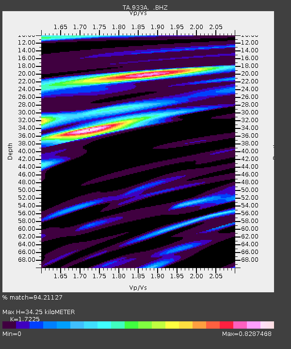
| Estimated Moho Depth: |
34.25 km |
| Estimated Crust Vp/Vs: |
1.72 |
| Assumed Crust Vp: |
6.096 km/s |
| Estimated Crust Vs: |
3.539 km/s |
| Estimated Crust Poisson's Ratio: |
0.25 |
|
| Radial Match: |
94.21127 % |
| Radial Bump: |
400 |
| Transverse Match: |
90.18356 % |
| Transverse Bump: |
400 |
| SOD ConfigId: |
299721 |
| Insert Time: |
2010-04-26 22:35:43.802 +0000 |
| GWidth: |
2.5 |
| Max Bumps: |
400 |
| Tol: |
0.001 |
|

Signal To Noise
| Channel | StoN | STA | LTA |
| TA:933A: :BHZ:20100311T14:50:04.299976Z | 11.227423 | 2.94431E-6 | 2.6224274E-7 |
| TA:933A: :BHN:20100311T14:50:04.299976Z | 3.0862358 | 8.7385615E-7 | 2.8314628E-7 |
| TA:933A: :BHE:20100311T14:50:04.299976Z | 1.9095896 | 5.189264E-7 | 2.7174758E-7 |
| Arrivals |
| Ps | 4.2 SECOND |
| PpPs | 15 SECOND |
| PsPs/PpSs | 19 SECOND |


