You are here: Home > Network List > TA - USArray Transportable Network (new EarthScope stations) Stations List
> Station 636A Smothers Creek Ranch, Halletsville, TX, USA > Earthquake Result Viewer
636A Smothers Creek Ranch, Halletsville, TX, USA - Earthquake Result Viewer

| Earthquake location: |
Near Coast Of Central Chile |
| Earthquake latitude/longitude: |
-34.3/-71.9 |
| Earthquake time(UTC): |
2010/03/11 (070) 14:39:43 GMT |
| Earthquake Depth: |
11 km |
| Earthquake Magnitude: |
6.7 MB, 7.0 MS, 6.9 MW, 6.9 MW |
| Earthquake Catalog/Contributor: |
WHDF/NEIC |
|
| Network: |
TA USArray Transportable Network (new EarthScope stations) |
| Station: |
636A Smothers Creek Ranch, Halletsville, TX, USA |
| Lat/Lon: |
29.48 N/97.06 W |
| Elevation: |
90 m |
|
| Distance: |
67.7 deg |
| Az: |
336.382 deg |
| Baz: |
157.64 deg |
| Ray Param: |
0.05675733 |
| Estimated Moho Depth: |
10.0 km |
| Estimated Crust Vp/Vs: |
1.66 |
| Assumed Crust Vp: |
5.78 km/s |
| Estimated Crust Vs: |
3.487 km/s |
| Estimated Crust Poisson's Ratio: |
0.21 |
|
| Radial Match: |
96.89157 % |
| Radial Bump: |
400 |
| Transverse Match: |
89.55181 % |
| Transverse Bump: |
400 |
| SOD ConfigId: |
299721 |
| Insert Time: |
2010-04-26 22:36:35.196 +0000 |
| GWidth: |
2.5 |
| Max Bumps: |
400 |
| Tol: |
0.001 |
|
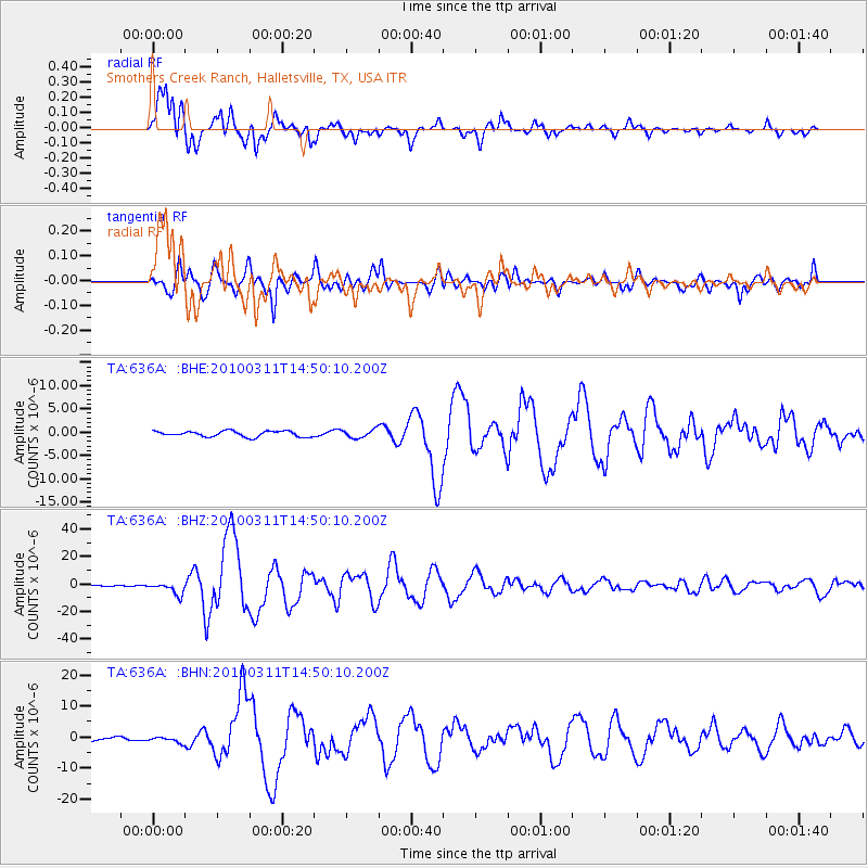
Signal To Noise
| Channel | StoN | STA | LTA |
| TA:636A: :BHZ:20100311T14:50:10.200Z | 14.71604 | 4.3444643E-6 | 2.9521965E-7 |
| TA:636A: :BHN:20100311T14:50:10.200Z | 1.354465 | 9.131663E-7 | 6.7418966E-7 |
| TA:636A: :BHE:20100311T14:50:10.200Z | 1.4743879 | 8.853764E-7 | 6.005044E-7 |
| Arrivals |
| Ps | 1.2 SECOND |
| PpPs | 4.4 SECOND |
| PsPs/PpSs | 5.6 SECOND |


