You are here: Home > Network List > TA - USArray Transportable Network (new EarthScope stations) Stations List
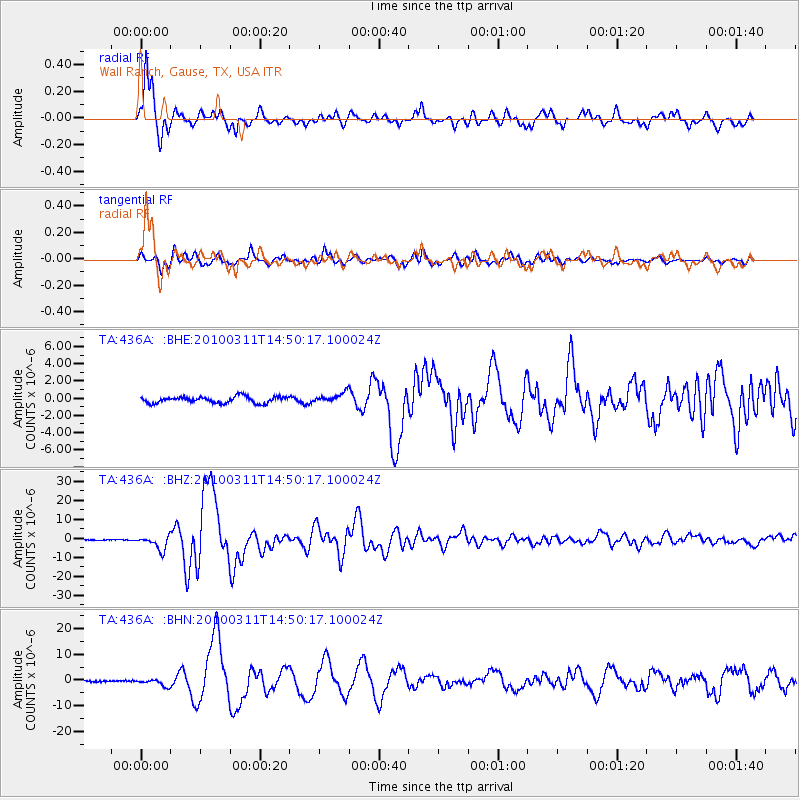
> Station 436A Wall Ranch, Gause, TX, USA > Earthquake Result Viewer
436A Wall Ranch, Gause, TX, USA - Earthquake Result Viewer
| Earthquake location: |
Near Coast Of Central Chile |
| Earthquake latitude/longitude: |
-34.3/-71.9 |
| Earthquake time(UTC): |
2010/03/11 (070) 14:39:43 GMT |
| Earthquake Depth: |
11 km |
| Earthquake Magnitude: |
6.7 MB, 7.0 MS, 6.9 MW, 6.9 MW |
| Earthquake Catalog/Contributor: |
WHDF/NEIC |
|
| Network: |
TA USArray Transportable Network (new EarthScope stations) |
| Station: |
436A Wall Ranch, Gause, TX, USA |
| Lat/Lon: |
30.77 N/96.80 W |
| Elevation: |
109 m |
|
| Distance: |
68.8 deg |
| Az: |
337.129 deg |
| Baz: |
158.046 deg |
| Ray Param: |
0.056035507 |
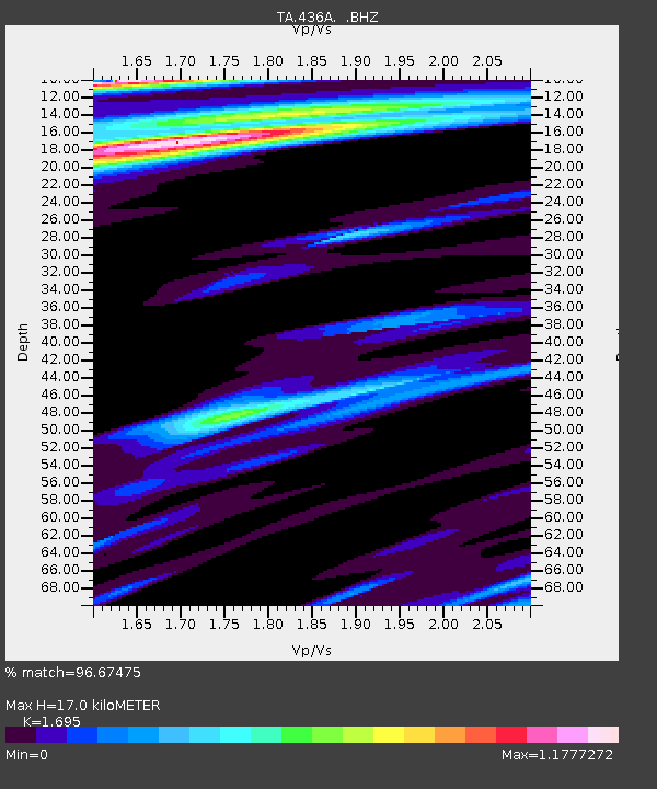
| Estimated Moho Depth: |
17.0 km |
| Estimated Crust Vp/Vs: |
1.70 |
| Assumed Crust Vp: |
6.347 km/s |
| Estimated Crust Vs: |
3.745 km/s |
| Estimated Crust Poisson's Ratio: |
0.23 |
|
| Radial Match: |
96.67475 % |
| Radial Bump: |
356 |
| Transverse Match: |
93.999695 % |
| Transverse Bump: |
400 |
| SOD ConfigId: |
299721 |
| Insert Time: |
2010-04-26 22:36:42.961 +0000 |
| GWidth: |
2.5 |
| Max Bumps: |
400 |
| Tol: |
0.001 |
|
Signal To Noise
| Channel | StoN | STA | LTA |
| TA:436A: :BHZ:20100311T14:50:17.100024Z | 18.352755 | 3.6426247E-6 | 1.9847836E-7 |
| TA:436A: :BHN:20100311T14:50:17.100024Z | 2.3914528 | 1.4179041E-6 | 5.929048E-7 |
| TA:436A: :BHE:20100311T14:50:17.100024Z | 1.6042093 | 5.910263E-7 | 3.684222E-7 |
| Arrivals |
| Ps | 1.9 SECOND |
| PpPs | 6.9 SECOND |
| PsPs/PpSs | 8.9 SECOND |


